1940s Maps of Saint Croix County, Wisconsin
Explore 13 historic maps of Saint Croix County from the 1940s. These maps offer a rare glimpse into what life looked like during the 1940s — showing old roads, neighborhoods, homes, and landmarks that have changed or disappeared over time.
Whether you're researching your family's past, planning a metal detecting trip, or studying how Saint Croix County's landscape evolved across the 1940s, these high-resolution maps are a powerful tool for exploring the history of this region.
- Focus on a specific era: All maps on this page are from the 1940s, giving you a focused view of this time period.
- See what’s changed: Compare century-old streets, trails, and buildings to today's modern landscape using overlays and satellite layers.
- Research with precision: Use these maps for genealogy, historical research, land use analysis, or educational projects.
- View, download, or print: Maps are fully viewable online in high resolution, and can be downloaded or printed for your own records.
Start exploring Saint Croix County's history through authentic maps from the 1940s. This is your window into the past.
Saint Croix County, WI maps
(13)- 1946 Map of Hudson, 1954 Print
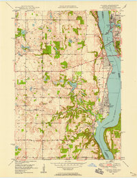
 1946 Hudson1954 Print · USGSThe riverfront communities of the St. Croix Valley are captured here just after the war, showing the distinct border towns of Wisconsin. Genealogists and local historians can trace the streets and benchmarks of Hudson, North Hudson, and Prescott.
 - 1946 Map of Knapp, 1967 Print
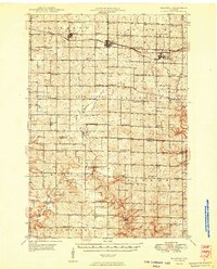
 1946 Knapp1967 Print · USGSThe borderlands of St. Croix, Pierce, and Dunn Counties come to life in this mid-century survey of the Wisconsin dairy country. Genealogists can locate dozens of country schools like Broadview Sch and Denver Sch, as well as the Dunkard Ch and Teegarden Cem.
 - 1946 Map of River Falls, 1968 Print
 1946 River Falls1968 Print · USGSPierce and St. Croix counties come alive in the mid-1940s, centered on the river-fed hub of River Falls. Genealogists and historians can trace dozens of rural schoolhouses and country churches, including Cherma Ch, Lafette Sch, and Glover.
 - 1948 Map of New Richmond, 1957 Print
 1948 New Richmond1957 Print · USGSSt. Croix County at the close of the 1940s shows a landscape of river-powered hamlets and rural school districts. Genealogists can trace family footprints through sites like Schroeder Cem, Emanuel Ch, and numerous schoolhouses from Lonesome Trail Sch to Elm Park Sch.3 unique versions available
 - 1948 Map of Stillwater, 1962 Print
 1948 Stillwater1962 Print · USGSThe St. Croix River valley comes to life in the late 1940s, capturing the river border between Minnesota and Wisconsin. Trace local genealogy and geography through the streets of Houlton, the Houlton Cem, and the historic Marine Ferry crossing.2 unique versions available
 - 1948 Map of Downing, 1970 Print
 1948 Downing1970 Print · USGSWestern Wisconsin's agricultural and rail heartland is captured here in the late 1940s, centered on the villages of the Tiffany Creek valley. Genealogists can trace family roots through dozens of rural landmarks like Beaver Valley Sch, Graytown, and Immanuel Ch.
 - 1949 Map of New Richmond
 1949 New Richmond1949 Print · USGSSt. Croix County at the end of the 1940s reveals a landscape of thriving rural townships and river-driven commerce. Genealogists and historians can trace defunct rail stops like Burkhardt Sta and dozens of country schools, including Lonesome Trail Sch and Oak Hill Sch.
 - 1949 Map of River Falls
 1949 River Falls1949 Print · USGSThe St. Croix and Pierce County borderlands near the late 1940s reveal a landscape of tight-knit rural communities and bustling riverside towns. Genealogists can trace family roots through dozens of local landmarks like Cherma Ch, Warren Cem, and the Nineteen Hundred Sch.2 unique versions available
 - 1949 Map of Hudson
 1949 Hudson1949 Print · USGSThe riverfront communities of St. Croix and Pierce counties are captured here in the late 1940s as the rail-and-river economy flourished. Genealogists and historians can trace the paths of the Chicago St Paul Minneapolis and Omaha line through Hudson and down to the river junction at Prescott.
 - 1949 Map of Knapp
 1949 Knapp1949 Print · USGSDunn, St. Croix, and Pierce counties come together in the late 1940s, showing a landscape defined by small-scale farming and the rail corridor. Genealogists can locate dozens of country schools and churches like Wilson Ch, East Hill Sch, and Hatchville Ch.
 - 1949 Map of Baldwin
 1949 Baldwin1949 Print · USGSThe dairy lands of St. Croix and Pierce counties thrive in the late 1940s as the rail line connects the bustling hubs of Baldwin and Woodville. Genealogists and historians can locate dozens of neighborhood landmarks, from the Emmanuel Lutheran Ch to rural schools like Birchdale Sch and Loyalty Sch.2 unique versions available
 - 1949 Map of Stillwater
 1949 Stillwater1949 Print · USGSThe St Croix River valley in the late 1940s shows the border settlements of Minnesota and Wisconsin before modern sprawl. Researchers can trace the layout of Houlton, find the Houlton Cem, and locate the Boy Scout Camp along the wooded river bluffs.2 unique versions available
 - 1949 Map of Hudson, 1958 Print
 1949 Hudson1958 Print · USGSThe St. Croix River valley at mid-century was a landscape of rail-connected river towns and small school districts. Genealogists can trace family roots through numerous local sites like Swede Hill Sch, St Peters Sch, and Lakeview Cem.2 unique versions available
End of results
Showing maps 1-13 of 13
Top cities of Saint Croix County
- Hudson historical maps
- New Richmond historical maps
- Baldwin historical maps
- North Hudson historical maps
- Somerset historical maps
- Roberts historical maps
See more
Frequently asked questions
- What are the different types of historical maps available for Saint Croix County?
- What is the oldest map of Saint Croix County?
- Where can I purchase historical maps of Saint Croix County for my home or office?
- Where can I download high-res historical maps of Saint Croix County?
- Are there historical topographic maps available for Saint Croix County?
- Is there historical aerial imagery available for Saint Croix County?
- Where are historical maps of Saint Croix County sourced from?