
1946 Map of Hudson
USGS Topo · Published 1954About this map
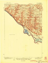
Lake St Croix serves as the dominant geographical feature of this mid-1940s survey, marking the watery border between Minnesota and Wisconsin. The map focuses on the eastern shoreline, highlighting the riverfront settlements of North Hudson and the city of Hudson, where the landscape is defined by the steep bluffs rising from the water. Further south, the confluence of the Mississippi River and the St. Croix is anchored by the town of Prescott. The river's navigation and local fishing spots are identified by landmarks like Catfish Bar and Black Bass Bar, while a large portion of the western Minnesota side remains designated as an Unsurveyed Area. This contrast emphasizes the concentration of development and infrastructure on the Wisconsin side during this post-war period.
Find a feature on this map
12 named features on this map. Tap any name to fly to it.
Don’t see what you’re looking for? This feature index may not catch every label — zoom into the map to look around manually.
Map Details
Editions of this 1946 Hudson Map
This is the sole edition of this map. No revisions or reprints were ever made.
Other maps of this area

1896 · St. Paul
USGS Topo · 1:62,500

1902 · White Bear
USGS Topo · 1:62,500
1944 · Red Wing
USGS Topo · 1:62,500

1946 · River Falls
USGS Topo · 1:62,500

1948 · New Richmond
USGS Topo · 1:62,500

1948 · Stillwater
USGS Topo · 1:62,500

1949 · New Richmond
USGS Topo · 1:62,500

1949 · River Falls
USGS Topo · 1:62,500

1949 · Hudson
USGS Topo · 1:62,500

1949 · Stillwater
USGS Topo · 1:62,500