
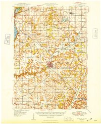
1949 Map of River Falls
USGS Topo · Published 1949About this map
River Falls and the borderlands of St Croix and Pierce counties are defined by the winding course of the Kinnickinnic River and its South Fork. This mid-century landscape is marked by a remarkably dense network of rural schoolhouses, such as Nineteen Hundred Sch, Liberty Hill Sch, and Glass Valley Sch, reflecting the localized educational structure before district consolidation. The Chicago and North Western railroad provides a vital industrial link through Hudson and Roberts, while the southern reaches near Beldenville transition into the valley of the Trimbelle River. Cultural landmarks like Mann Valley Ch and the German Settlement Cem offer tangible evidence of the immigrant communities that settled these fertile uplands, creating a detailed record of the area's social and geographic development.
Find a feature on this map
65 named features on this map. Tap any name to fly to it.
Don’t see what you’re looking for? This feature index may not catch every label — zoom into the map to look around manually.
Map Details
Editions of this 1949 River Falls Map
2 editions found
Other maps of this area

1940 · Maiden Rock
USGS Topo · 1:62,500

1944 · Red Wing
USGS Topo · 1:62,500

1946 · Hudson
USGS Topo · 1:62,500

1946 · River Falls
USGS Topo · 1:62,500

1948 · New Richmond
USGS Topo · 1:62,500

1948 · Stillwater
USGS Topo · 1:62,500

1949 · New Richmond
USGS Topo · 1:62,500

1949 · Hudson
USGS Topo · 1:62,500

1949 · Baldwin
USGS Topo · 1:62,500

1949 · Stillwater
USGS Topo · 1:62,500