1946 Map of River Falls
USGS Topo · Published 1968About this map
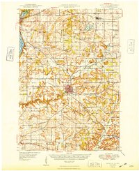
River Falls serves as the focal point of this mid-century landscape, positioned at the confluence where the Kinnickinnic River meets its South Fork. The town is characterized by its educational and recreational landmarks, notably the State Teachers College and the River Falls Golf Course. This era shows a dense network of rural infrastructure, where nearly every township section supports a namesake schoolhouse, such as Nineteen Hundred Sch, Glass Valley Sch, and Monument Sch. To the northwest, Hudson sits along the banks of Lake St Croix, while the Chicago and North Western railroad provides a vital transportation spine connecting these river valley communities. The map preserves the locations of several small cultural centers, including the Kinnickinnic Ch and the German Settlement Cem, illustrating the organized settlement patterns of Pierce and St. Croix counties.
Find a feature on this map
64 named features on this map. Tap any name to fly to it.
Don’t see what you’re looking for? This feature index may not catch every label — zoom into the map to look around manually.
Map Details
Editions of this 1946 River Falls Map
This is the sole edition of this map. No revisions or reprints were ever made.