
1949 Map of Stillwater
USGS Topo · Published 1949About this map
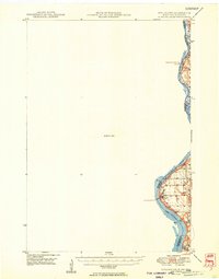
The St Croix River serves as the focal point of this late 1940s survey, marking the jagged boundary between Minnesota and Wisconsin. While a significant portion of the sheet is designated as an Unmapped Area, the surveyed corridor reveals the river-bluff landscape of the borderlands. The settlement of Houlton stands as a primary outpost on the Wisconsin side, supported by local landmarks like the Houlton Cem and a nearby Tower. Further south, North Hudson sits along the widening waters of Lake St Croix, illustrating the early post-war residential expansion near the river. The presence of a Boy Scout Camp along the shoreline highlights the era's recreational use of the valley's wooded fringes, before more intensive development altered the landscape of Washington County and St Croix County.
Find a feature on this map
10 named features on this map. Tap any name to fly to it.
Don’t see what you’re looking for? This feature index may not catch every label — zoom into the map to look around manually.
Map Details
Editions of this 1949 Stillwater Map
2 editions found
Other maps of this area

1896 · St. Paul
USGS Topo · 1:62,500

1900 · St Croix Dalles
USGS Topo · 1:62,500

1901 · St Croix Dalles
USGS Topo · 1:62,500

1902 · White Bear
USGS Topo · 1:62,500

1946 · Hudson
USGS Topo · 1:62,500

1946 · River Falls
USGS Topo · 1:62,500

1948 · New Richmond
USGS Topo · 1:62,500

1948 · Stillwater
USGS Topo · 1:62,500

1949 · New Richmond
USGS Topo · 1:62,500

1949 · River Falls
USGS Topo · 1:62,500