
1900 Map of St Croix Dalles
USGS Topo · Published 1900About this map
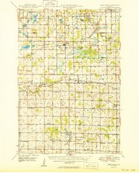
The St. Croix River carves a deep boundary between Wisconsin and Minnesota at the turn of the century, anchoring a landscape defined by glacial lakes and early rail development. Surveyed in 1897, this topographic study reveals the industrial and transit hubs of Taylors Falls and St. Croix Falls positioned directly across from one another at the river's bend. The arrival of the Minneapolis St. Paul and Sault Ste. Marie Ry. and the St. Paul and Duluth R.R. transformed the region, connecting remote settlements like Shafer and Franconia to larger markets. Away from the river, the map detail shows a dense concentration of water bodies such as Deer Lake and Big Lake, which shaped the rural townships of Osceola and Alden. These topographic contours illustrate the complex drainage patterns and the established road networks of the late 19th-century frontier.
Find a feature on this map
75 named features on this map. Tap any name to fly to it.
Don’t see what you’re looking for? This feature index may not catch every label — zoom into the map to look around manually.
Map Details
Editions of this 1900 St Croix Dalles Map
This is the sole edition of this map. No revisions or reprints were ever made.
Other maps of this area

1901 · St Croix Dalles
USGS Topo · 1:62,500

1948 · New Richmond
USGS Topo · 1:62,500

1948 · Stillwater
USGS Topo · 1:62,500

1949 · New Richmond
USGS Topo · 1:62,500

1949 · Stillwater
USGS Topo · 1:62,500

1950 · Rush City
USGS Topo · 1:48,000
1950 · Deer Park
USGS Topo · 1:62,500

1950 · Balsam Lake
USGS Topo · 1:62,500

1951 · Milltown
USGS Topo · 1:48,000
1951 · Frederic
USGS Topo · 1:48,000
Featured Places
- Osceola, WI
- Town of Osceola, Osceola
- Town of Farmington, Farmington
- Franconia, Franconia Township
- Taylors Falls, MN