1970s Maps of Rush River, Wisconsin
Explore 4 historic maps of Rush River from the 1970s. These maps offer a rare glimpse into what life looked like during the 1970s — showing old roads, neighborhoods, homes, and landmarks that have changed or disappeared over time.
Whether you're researching your family's past, planning a metal detecting trip, or studying how Rush River's landscape evolved across the 1970s, these high-resolution maps are a powerful tool for exploring the history of this region.
- Focus on a specific era: All maps on this page are from the 1970s, giving you a focused view of this time period.
- See what’s changed: Compare century-old streets, trails, and buildings to today's modern landscape using overlays and satellite layers.
- Research with precision: Use these maps for genealogy, historical research, land use analysis, or educational projects.
- View, download, or print: Maps are fully viewable online in high resolution, and can be downloaded or printed for your own records.
Start exploring Rush River's history through authentic maps from the 1970s. This is your window into the past.
Rush River, WI maps
(4)- 1974 Map of El Paso, 1977 Print
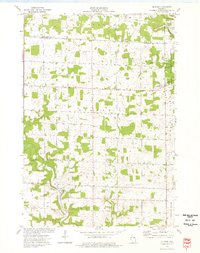 1974 El Paso1977 Print · USGSPierce County and the Rush River valley are captured in the mid-1970s, showcasing a landscape of ridge-top farms and deep coulees. Researchers can locate family landmarks such as Gilman Sch, the Sacred Heart Ch, and the landmark Crystal Cave.
 - 1974 Map of Baldwin East, 1977 Print
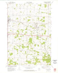 1974 Baldwin East1977 Print · USGSSt. Croix County during the mid-seventies reveals a landscape of growing villages and a steady rail-and-river economy. Researchers can trace the Chicago and North Western line or locate family plots at Lone Pine Cem and Brookville Cem.
 - 1974 Map of Baldwin West, 1977 Print
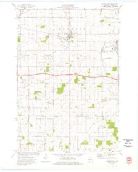 1974 Baldwin West1977 Print · USGSMid-century St. Croix County comes into focus as the Chicago and North Western railroad links the growing hubs of Hammond and Baldwin. Genealogists and local researchers can trace rural landmarks from the Catholic Cem to the Baldwin Christian Sch and the Peace Ch.
 - 1974 Map of Martell, 1977 Print
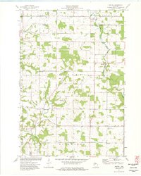 1974 Martell1977 Print · USGSWestern Wisconsin's agricultural heartland is documented in the mid-1970s, showcasing the rural crossroads of Pierce County. Genealogists can locate family landmarks like Sunnyside Sch, Mt Olivet Cem, and the Rush River Ch.
End of results
Showing maps 1-4 of 4
Top cities near Rush River
- River Falls historical maps
- New Richmond historical maps
- Baldwin historical maps
- Ellsworth historical maps
- River Falls historical maps
- Town of River Falls historical maps
See more
Top neighborhoods of Rush River
Frequently asked questions
- What are the different types of historical maps available for Rush River?
- What is the oldest map of Rush River?
- Where can I purchase historical maps of Rush River for my home or office?
- Where can I download high-res historical maps of Rush River?
- Are there historical topographic maps available for Rush River?
- Is there historical aerial imagery available for Rush River?
- Where are historical maps of Rush River sourced from?