2020s Maps of Johannesburg, Star Prairie
Explore 1 historic maps of Johannesburg from the 2020s. These maps offer a rare glimpse into what life looked like during the 2020s — showing old roads, neighborhoods, homes, and landmarks that have changed or disappeared over time.
Whether you're researching your family's past, planning a metal detecting trip, or studying how Johannesburg's landscape evolved across the 2020s, these high-resolution maps are a powerful tool for exploring the history of this region.
- Focus on a specific era: All maps on this page are from the 2020s, giving you a focused view of this time period.
- See what’s changed: Compare century-old streets, trails, and buildings to today's modern landscape using overlays and satellite layers.
- Research with precision: Use these maps for genealogy, historical research, land use analysis, or educational projects.
- View, download, or print: Maps are fully viewable online in high resolution, and can be downloaded or printed for your own records.
Start exploring Johannesburg's history through authentic maps from the 2020s. This is your window into the past.
Johannesburg, Star Prairie maps
(1)- 2023 Map of New Richmond North, 2023 Print
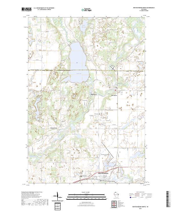 2023 New Richmond North2023 Print · USGSThe St. Croix and Polk county line area near New Richmond is shown here in the 2020s, characterized by its glacial lakes and dedicated waterfowl production areas. Researchers can locate local landmarks like Oakland Cem, Danielson Field, and the small settlement of Huntington along the Apple River.
End of results
Showing maps 1-1 of 1
Top cities near Johannesburg
- Stillwater historical maps
- Hudson historical maps
- New Richmond historical maps
- Baldwin historical maps
- Oak Park Heights historical maps
- Lindström historical maps
See more
Frequently asked questions
- What are the different types of historical maps available for Johannesburg?
- What is the oldest map of Johannesburg?
- Where can I purchase historical maps of Johannesburg for my home or office?
- Where can I download high-res historical maps of Johannesburg?
- Are there historical topographic maps available for Johannesburg?
- Is there historical aerial imagery available for Johannesburg?
- Where are historical maps of Johannesburg sourced from?