1960s Maps of Prairie du Sac, Wisconsin
Explore 5 historic maps of Prairie du Sac from the 1960s. These maps offer a rare glimpse into what life looked like during the 1960s — showing old roads, neighborhoods, homes, and landmarks that have changed or disappeared over time.
Whether you're researching your family's past, planning a metal detecting trip, or studying how Prairie du Sac's landscape evolved across the 1960s, these high-resolution maps are a powerful tool for exploring the history of this region.
- Focus on a specific era: All maps on this page are from the 1960s, giving you a focused view of this time period.
- See what’s changed: Compare century-old streets, trails, and buildings to today's modern landscape using overlays and satellite layers.
- Research with precision: Use these maps for genealogy, historical research, land use analysis, or educational projects.
- View, download, or print: Maps are fully viewable online in high resolution, and can be downloaded or printed for your own records.
Start exploring Prairie du Sac's history through authentic maps from the 1960s. This is your window into the past.
Prairie du Sac, WI maps
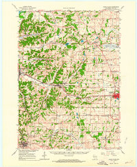
(5)- 1960 Map of Madison
 1960 Madison1960 Print · USGSCentral and Southern Wisconsin are captured in the late fifties, showing the region as its rail-and-river network matured. Trace the paths of the Soo Line RR or locate family roots near Lake Mendota and Horicon National Wildlife Refuge.2 unique versions available
 - 1962 Map of Cross Plains, 1964 Print
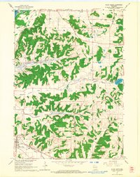
 1962 Cross Plains1964 Print · USGSWestern Dane County in the early sixties shows a landscape of deep valleys and rising ridges between Cross Plains and Mt Horeb. Genealogists and historians can trace family locations through numerous rural sites like St Marys Cem, Richardson Cave, and the Pine Bluff Observatory.2 unique versions available
 - 1962 Map of Black Earth, 1964 Print
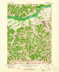
 1962 Black Earth1964 Print · USGSDane County's ridge-and-valley landscape is documented here in the early sixties, showing the rural crossroads and rail corridors of the Driftless Area. You can locate family history at St Johns Ch or trace the old rail line near Black Earth and Table Bluff.2 unique versions available
 - 1962 Map of Blue Mounds, 1964 Print
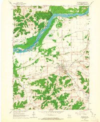
 1962 Blue Mounds1964 Print · USGSThe Wisconsin River valley and the driftless hills of Dane County are captured here in the early sixties. Genealogists and hikers can trace old ridge roads to Little Norway, the White Church Cem, and the underground wonders of Cave of the Mounds.3 unique versions available
 - 1962 Map of Mazomanie, 1964 Print
 1962 Mazomanie1964 Print · USGSThe Wisconsin River valley comes alive in the early sixties, showing the vital rail-and-river connection between local settlements. Genealogists and historians can locate St Barnabas Ch, the Cassell Cem, and the tracks of the Chicago Milwaukee St Paul and Pacific railroad.3 unique versions available
End of results
Showing maps 1-5 of 5
Top cities near Prairie du Sac
- Madison historical maps
- Middleton historical maps
- Baraboo historical maps
- Cross Plains historical maps
- Prairie du Sac historical maps
- Sauk City historical maps
See more
Top neighborhoods of Prairie du Sac
Frequently asked questions
- What are the different types of historical maps available for Prairie du Sac?
- What is the oldest map of Prairie du Sac?
- Where can I purchase historical maps of Prairie du Sac for my home or office?
- Where can I download high-res historical maps of Prairie du Sac?
- Are there historical topographic maps available for Prairie du Sac?
- Is there historical aerial imagery available for Prairie du Sac?
- Where are historical maps of Prairie du Sac sourced from?