1970s Maps of Aurora, Wisconsin
Explore 4 historic maps of Aurora from the 1970s. These maps offer a rare glimpse into what life looked like during the 1970s — showing old roads, neighborhoods, homes, and landmarks that have changed or disappeared over time.
Whether you're researching your family's past, planning a metal detecting trip, or studying how Aurora's landscape evolved across the 1970s, these high-resolution maps are a powerful tool for exploring the history of this region.
- Focus on a specific era: All maps on this page are from the 1970s, giving you a focused view of this time period.
- See what’s changed: Compare century-old streets, trails, and buildings to today's modern landscape using overlays and satellite layers.
- Research with precision: Use these maps for genealogy, historical research, land use analysis, or educational projects.
- View, download, or print: Maps are fully viewable online in high resolution, and can be downloaded or printed for your own records.
Start exploring Aurora's history through authentic maps from the 1970s. This is your window into the past.
Aurora, WI maps
(4)- 1973 Map of Gilman, 1976 Print
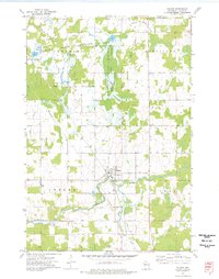 1973 Gilman1976 Print · USGSIn the early 1970s, this Taylor County landscape centered on Gilman and the winding Yellow River. Researchers can trace old transportation corridors along the Soo Line Railroad and the Old Railroad Grade or locate family plots at Meadowbrook Cem.2 unique versions available
 - 1973 Map of Bellinger, 1976 Print
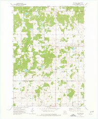 1973 Bellinger1976 Print · USGSTaylor and Clark counties are captured here in the early 1970s, showing a transition from the logging era to a quiet rural landscape. Researchers can trace the Old Railroad Grade and locate local landmarks like the Ukrainian Orthodox Ch and the settlement of Bellinger.
 - 1973 Map of Ruby, 1976 Print
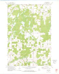 1973 Ruby1976 Print · USGSChippewa and Taylor counties in the early 1970s reveal a landscape of vast wetlands and managed wilderness. Genealogists and local historians can locate the Yellow River Cem and St Johns Ch near the banks of the Yellow River.
 - 1973 Map of Huron, 1976 Print
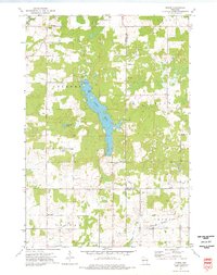 1973 Huron1976 Print · USGSWisconsin's lake country in the early 1970s is shown here at the intersection of Chippewa, Taylor, and Clark counties. Researchers can trace the Old Railroad Grade near Brownville or locate local landmarks like the Gilman Lookout Tower and Huron.
End of results
Showing maps 1-4 of 4
Top cities near Aurora
- Stanley historical maps
- Thorp historical maps
- Edson historical maps
- Owen historical maps
- Colburn historical maps
- Reseburg historical maps
See more
Frequently asked questions
- What are the different types of historical maps available for Aurora?
- What is the oldest map of Aurora?
- Where can I purchase historical maps of Aurora for my home or office?
- Where can I download high-res historical maps of Aurora?
- Are there historical topographic maps available for Aurora?
- Is there historical aerial imagery available for Aurora?
- Where are historical maps of Aurora sourced from?