1900s (20th Century) Maps of Sunrise, Phelps
Explore 10 historic maps of Sunrise from the 1900s (20th Century). These maps offer a rare glimpse into what life looked like during the 1900s — showing old roads, neighborhoods, homes, and landmarks that have changed or disappeared over time.
Whether you're researching your family's past, planning a metal detecting trip, or studying how Sunrise's landscape evolved across the 1900s, these high-resolution maps are a powerful tool for exploring the history of this region.
- Focus on a specific era: All maps on this page are from the 1900s, giving you a focused view of this time period.
- See what’s changed: Compare century-old streets, trails, and buildings to today's modern landscape using overlays and satellite layers.
- Research with precision: Use these maps for genealogy, historical research, land use analysis, or educational projects.
- View, download, or print: Maps are fully viewable online in high resolution, and can be downloaded or printed for your own records.
Start exploring Sunrise's history through authentic maps from the 1900s. This is your window into the past.
Sunrise, Phelps maps
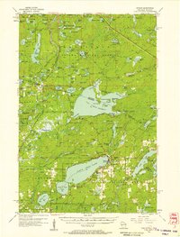
(10)- 1938 Map of Phelps, 1946 Print
 1938 Phelps1946 Print · USGSVilas County's northern lakes and timberlands come into focus during the late 1930s, showing a landscape defined by the Michigan-Wisconsin state line and new conservation camps. Genealogists and historians can trace the foundations of local life at the Augustus Adolphus Ch, Conover Cem, and the CCC Camp near Phelps.
 - 1950 Map of Phelps
 1950 Phelps1950 Print · USGSVilas County's lake country is captured here during the mid-century, showing the development of Phelps and Land O' Lakes along the state line. Researchers can trace the Chicago and Northwestern rail line and locate the Augustus Adolphus Ch or the C C C Camp near Afterglow Lake.
 - 1956 Map of Phelps, 1957 Print
 1956 Phelps1957 Print · USGSVilas County and the Michigan border country are captured here in the mid-fifties, at the height of the Northwoods' timber and rail era. Researchers can locate the Kataktikon Indian Village, the Conover Cemetery, and the old Chicago and North Western rail line.4 unique versions available
 - 1958 Map of Iron River, 1968 Print
 1958 Iron River1968 Print · USGSThe Upper Peninsula in the late fifties is captured here as a landscape of timber, iron, and rail. Genealogists and historians can trace rail stops like Mass Station or explore the coastlines of Lake Gogebic and Keweenaw Bay.3 unique versions available
 - 1960 Map of Iron River
 1960 Iron River1960 Print · USGSThe Upper Peninsula’s western reaches are shown in the late fifties, featuring the industrial infrastructure of the Copper Country and the vast Ottawa National Forest. Researchers can trace the rail lines of the Milwaukee Road through settlements like Bruce Crossing and the White Pine Mine.
 - 1961 Map of Iron River
 1961 Iron River1961 Print · USGSThe Upper Peninsula and northern Wisconsin are shown here in the early 1960s, a landscape defined by the iron range and vast timberlands. Researchers can trace the legacy of mining and rail transport through Caspian, the Lac Du Flambeau Indian Reservation, and the Milwaukee Road.
 - 1967 Map of Iron River, 1968 Print
 1967 Iron River1968 Print · USGSThe Upper Peninsula and northern Wisconsin borderlands are shown here in the late sixties, a landscape of deep woods and iron-country rail lines. Genealogists and historians can trace the lakeside settlements of L'Anse and Ontonagon or follow the Soo Line through towns like Michigamme and Nestoria.
 - 1982 Map of Land O'Lakes
 1982 Land O'Lakes1982 Print · USGSThe Wisconsin-Michigan border country comes alive in the early eighties, centered on the rail-and-lake hub of Land O' Lakes. Trace family history at Land O' Lakes Cemetery or locate historic lakeside sites like Reimers Island and Wilson Springs.
 - 1990 Map of Wakefield
 1990 Wakefield1990 Print · USGSThe Michigan-Wisconsin borderlands are captured here in the late twentieth century, showing the transition from an industrial rail-and-timber hub to a recreation-focused landscape. Trace the Chicago & North Western RR through Marenisco or locate landmarks like Agate Falls and Wakefield.
 - 1999 Map of Land O'Lakes, 2005 Print
 1999 Land O'Lakes2005 Print · USGSThe Wisconsin-Michigan border country comes into sharp focus during the late 1990s, revealing a landscape defined by Northwoods lakes and federal forest lands. Researchers can trace local landmarks like Land O' Lakes, the Sylvania Wilderness, and the Land O' Lakes Airport.
End of results
Showing maps 1-10 of 10
Top cities near Sunrise
- Washington historical maps
- Eagle River historical maps
- Phelps historical maps
- Watersmeet historical maps
- Conover historical maps
- Hiles historical maps
See more
Frequently asked questions
- What are the different types of historical maps available for Sunrise?
- What is the oldest map of Sunrise?
- Where can I purchase historical maps of Sunrise for my home or office?
- Where can I download high-res historical maps of Sunrise?
- Are there historical topographic maps available for Sunrise?
- Is there historical aerial imagery available for Sunrise?
- Where are historical maps of Sunrise sourced from?