2020s Maps of Washington County, Wisconsin
Explore 16 historic maps of Washington County from the 2020s. These maps offer a rare glimpse into what life looked like during the 2020s — showing old roads, neighborhoods, homes, and landmarks that have changed or disappeared over time.
Whether you're researching your family's past, planning a metal detecting trip, or studying how Washington County's landscape evolved across the 2020s, these high-resolution maps are a powerful tool for exploring the history of this region.
- Focus on a specific era: All maps on this page are from the 2020s, giving you a focused view of this time period.
- See what’s changed: Compare century-old streets, trails, and buildings to today's modern landscape using overlays and satellite layers.
- Research with precision: Use these maps for genealogy, historical research, land use analysis, or educational projects.
- View, download, or print: Maps are fully viewable online in high resolution, and can be downloaded or printed for your own records.
Start exploring Washington County's history through authentic maps from the 2020s. This is your window into the past.
Washington County, WI maps
(16)- 2022 Map of West Bend, 2022 Print
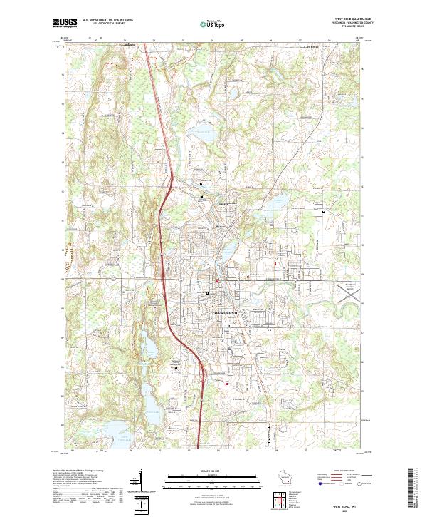 2022 West Bend2022 Print · USGSModern-day Washington County comes into focus as the glacial terrain of the Kettle Moraine meets the historic riverfronts of West Bend and Barton. Researchers can trace local heritage at Holy Angels Cem and the University of Wisconsin - Washington County.
 - 2022 Map of Hartford East, 2022 Print
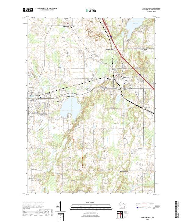 2022 Hartford East2022 Print · USGSThe glacial landscapes of Washington County are captured here in a modern era, showing the transition from lakeside retreats to established towns. Genealogists can locate family sites near Saint Lawrence Cem, Ackerville, and Old Saint Peter Cem.
 - 2022 Map of Five Corners, 2022 Print
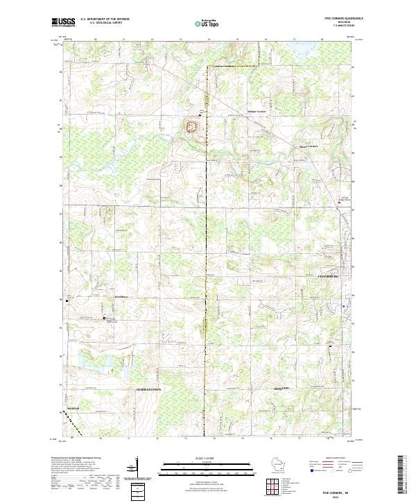 2022 Five Corners2022 Print · USGSThe Washington and Ozaukee county line area is shown in this 2022 survey, as modern growth meets historic crossroads. Trace the legacy of early settlements at Kirchhayn and find long-standing local landmarks like Saint Marys Cem and the Cedarburg Bog.
 - 2022 Map of Newburg, 2022 Print
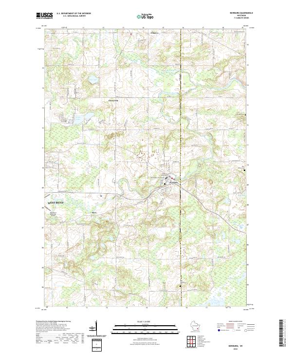 2022 Newburg2022 Print · USGSThe Milwaukee River valley in eastern Wisconsin comes alive in this 2022 survey, showing the interconnected rural communities of Washington and Ozaukee Counties. Researchers can trace local lineage through numerous sites like Newburg Union Cem, the Cedarburg Bog, and the settlement of Cheeseville.
 - 2022 Map of Allenton, 2022 Print
 2022 Allenton2022 Print · USGSWashington County at the start of the 2020s shows a landscape of enduring rural hamlets and glacial lakes. Local historians can trace family locations near Kohlsville, Allenton, and the Albright United Brethren Cem.
 - 2022 Map of Sussex, 2022 Print
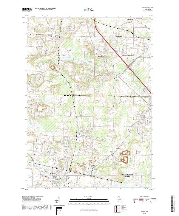 2022 Sussex2022 Print · USGSSoutheast Wisconsin's transition from rural townships to bustling residential centers is captured here during the early 2020s. Researchers can locate several burial grounds like Union Cemetery and trace the path of the Soo Line through Lannon and Sussex.
 - 2022 Map of Hartford West, 2022 Print
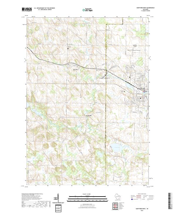 2022 Hartford West2022 Print · USGSEastern Dodge County is captured here in the early twenty-first century as agricultural lands meet the growing town of Hartford. Researchers can trace local lineage through Hallowell Farm Cem or explore the shores of Druid Lake and the Rubicon River.
 - 2022 Map of Lomira, 2022 Print
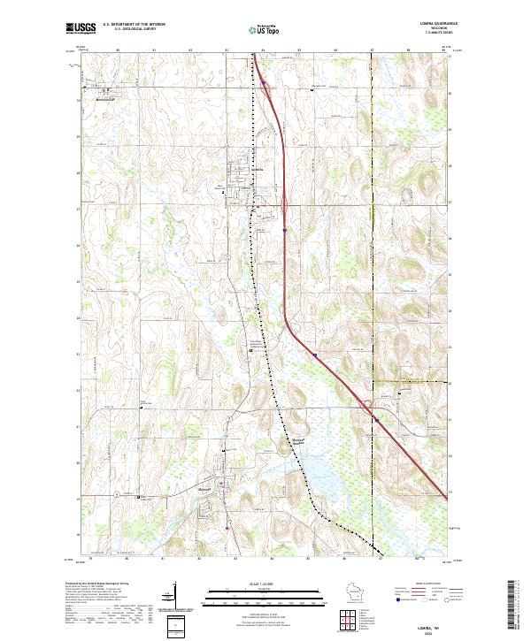 2022 Lomira2022 Print · USGSLomira and Theresa thrive amidst the glacial drumlins of Dodge County in this recent survey of the Wisconsin landscape. Genealogists can trace family heritage through local landmarks like Saint Pauls Evangelical Lutheran Cem, Theresa Station, and Crystal Spring.
 - 2022 Map of Campbellsport, 2022 Print
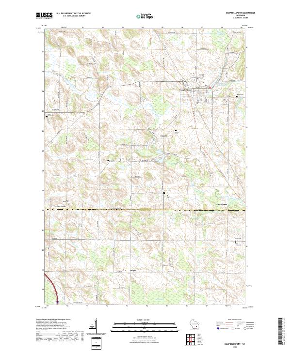 2022 Campbellsport2022 Print · USGSCampbellsport and its surrounding hamlets are captured here in the early 2020s, showing a landscape defined by the Milwaukee River and glacial terrain. Researchers can locate numerous local burial grounds like Auburn Cem and Rauch Cem or trace the drainage of Wayne Cr.
 - 2022 Map of Merton, 2022 Print
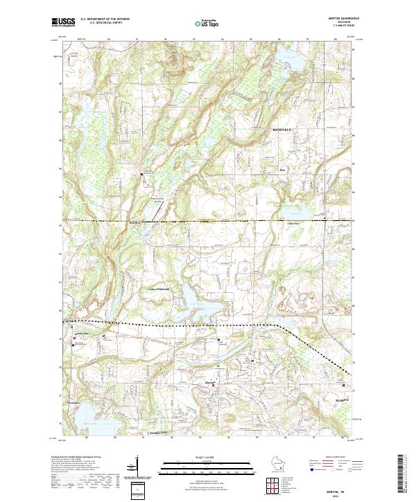 2022 Merton2022 Print · USGSWaukesha County's kettle moraine landscape is shown here in the early 2020s, featuring the interconnected river systems and lakes of Merton and Richfield. Researchers can trace local heritage through the Ice Age National Scenic Trail and sites like Saint Columba Cem and Monches Millpond 38.
 - 2022 Map of Jackson, 2022 Print
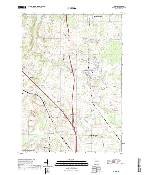 2022 Jackson2022 Print · USGSSoutheast Wisconsin in the twenty-first century remains a landscape where historic crossroads like Rugby Junction and Mayfield intersect with modern growth. Researchers can trace local heritage through several burial sites including Ackerville Cem and Last Home Cem.
 - 2022 Map of Batavia, 2022 Print
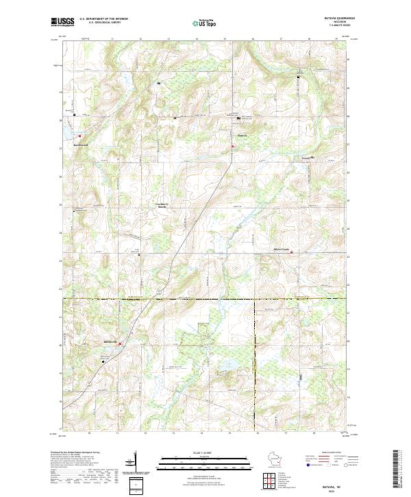 2022 Batavia2022 Print · USGSThe rural landscapes of Sheboygan and Washington counties are documented here in recent detail, showing a network of small hamlets and family farmsteads. Researchers can locate numerous pioneer burial sites such as Winfield Cem and trace the waters of the North Branch Milwaukee River past the Gooseville Millpond.
 - 2022 Map of Kewaskum, 2022 Print
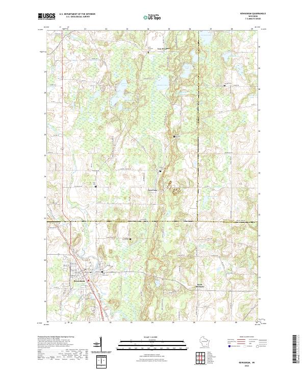 2022 Kewaskum2022 Print · USGSThe Kettle Moraine region in the early 2020s shows a complex landscape of glacial lakes and small river settlements. Researchers can trace family history through numerous rural burial sites like Saint Matthias Cem and Trinity Cem or explore the corridor of the Milwaukee River.
 - 2022 Map of Menomonee Falls, 2022 Print
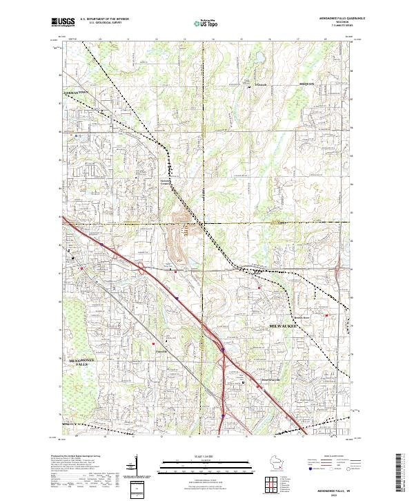 2022 Menomonee Falls2022 Print · USGSThe northern Milwaukee suburbs and the corners of four counties appear here in the early 2020s. Genealogists can locate numerous burial sites and former hamlets like Fussville, West Granville Cem, and Trinity Lutheran Cem Old.
 - 2022 Map of Stonebank, 2022 Print
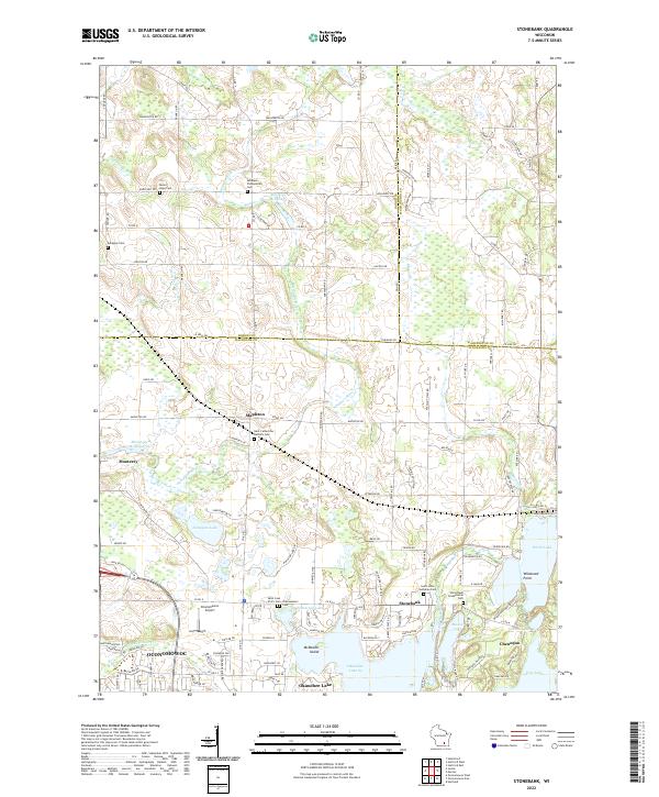 2022 Stonebank2022 Print · USGSWaukesha County's lake country is captured here in the early twenty-first century, showing the established communities of Stonebank and Chenequa. Researchers can trace local history through numerous sites like Saint Catherines Catholic Cem, Alderley Millpond, and Oconomowoc Airport.
 - 2022 Map of Nenno, 2022 Print
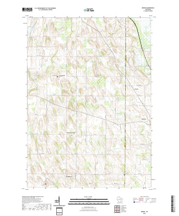 2022 Nenno2022 Print · USGSDodge and Washington counties are shown in this recent survey of Wisconsin’s dairy country. Researchers can trace family roots at Hochheim Cem and Reform Cem or locate old community centers like Nenno and Huilsburg.
End of results
Showing maps 1-16 of 16
Top cities of Washington County
- West Bend historical maps
- Germantown historical maps
- Hartford historical maps
- Richfield historical maps
- Jackson historical maps
- Slinger historical maps
See more
Frequently asked questions
- What are the different types of historical maps available for Washington County?
- What is the oldest map of Washington County?
- Where can I purchase historical maps of Washington County for my home or office?
- Where can I download high-res historical maps of Washington County?
- Are there historical topographic maps available for Washington County?
- Is there historical aerial imagery available for Washington County?
- Where are historical maps of Washington County sourced from?