1970s Maps of Kewaskum, Wisconsin
Explore 2 historic maps of Kewaskum from the 1970s. These maps offer a rare glimpse into what life looked like during the 1970s — showing old roads, neighborhoods, homes, and landmarks that have changed or disappeared over time.
Whether you're researching your family's past, planning a metal detecting trip, or studying how Kewaskum's landscape evolved across the 1970s, these high-resolution maps are a powerful tool for exploring the history of this region.
- Focus on a specific era: All maps on this page are from the 1970s, giving you a focused view of this time period.
- See what’s changed: Compare century-old streets, trails, and buildings to today's modern landscape using overlays and satellite layers.
- Research with precision: Use these maps for genealogy, historical research, land use analysis, or educational projects.
- View, download, or print: Maps are fully viewable online in high resolution, and can be downloaded or printed for your own records.
Start exploring Kewaskum's history through authentic maps from the 1970s. This is your window into the past.
Kewaskum, WI maps
(2)- 1974 Map of Kewaskum, 1977 Print
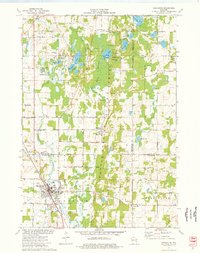 1974 Kewaskum1977 Print · USGSThe glacial landscapes of Washington and Sheboygan Counties are on full display in the mid-1970s, showcasing the intricate network of lakes and kettle formations. Researchers can trace rural life through the New Fane Millpond, early cemeteries like New Prospect Cem, and the Chicago and North Western rail corridor.
 - 1974 Map of Campbellsport, 1978 Print
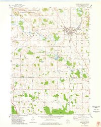 1974 Campbellsport1978 Print · USGSWisconsin's glacial legacy is on full display in the 1970s, as drumlin ridges and marshes define the landscape around Campbellsport. Family historians can locate several rural burial grounds like Union Cem and Deutsche Bisch Cem or trace the Chicago and North Western rail line.
End of results
Showing maps 1-2 of 2
Top cities near Kewaskum
- Fond du Lac historical maps
- West Bend historical maps
- Hartford historical maps
- Cedarburg historical maps
- Plymouth historical maps
- Jackson historical maps
See more
Frequently asked questions
- What are the different types of historical maps available for Kewaskum?
- What is the oldest map of Kewaskum?
- Where can I purchase historical maps of Kewaskum for my home or office?
- Where can I download high-res historical maps of Kewaskum?
- Are there historical topographic maps available for Kewaskum?
- Is there historical aerial imagery available for Kewaskum?
- Where are historical maps of Kewaskum sourced from?