1960s Maps of Coloma, Wisconsin
Explore 1 historic maps of Coloma from the 1960s. These maps offer a rare glimpse into what life looked like during the 1960s — showing old roads, neighborhoods, homes, and landmarks that have changed or disappeared over time.
Whether you're researching your family's past, planning a metal detecting trip, or studying how Coloma's landscape evolved across the 1960s, these high-resolution maps are a powerful tool for exploring the history of this region.
- Focus on a specific era: All maps on this page are from the 1960s, giving you a focused view of this time period.
- See what’s changed: Compare century-old streets, trails, and buildings to today's modern landscape using overlays and satellite layers.
- Research with precision: Use these maps for genealogy, historical research, land use analysis, or educational projects.
- View, download, or print: Maps are fully viewable online in high resolution, and can be downloaded or printed for your own records.
Start exploring Coloma's history through authentic maps from the 1960s. This is your window into the past.
Coloma, WI maps
(1)- 1968 Map of Coloma, 1971 Print
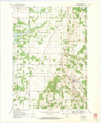 1968 Coloma1971 Print · USGSThe rural landscape of Waushara County in the late sixties is defined by its small settlements and distinct township boundaries. Genealogists and local historians can locate several country burial grounds like White Cem and the De George Sch, while tracing the path of the Old Railroad Grade.
End of results
Showing maps 1-1 of 1
Top cities near Coloma
- Packwaukee historical maps
- Easton historical maps
- Big Flats historical maps
- Plainfield historical maps
- Hancock historical maps
- Almond historical maps
See more
Frequently asked questions
- What are the different types of historical maps available for Coloma?
- What is the oldest map of Coloma?
- Where can I purchase historical maps of Coloma for my home or office?
- Where can I download high-res historical maps of Coloma?
- Are there historical topographic maps available for Coloma?
- Is there historical aerial imagery available for Coloma?
- Where are historical maps of Coloma sourced from?