Old Maps of Toltec, Wyoming for Genealogy
Trace your family roots with 9 historic maps of Toltec. These high-res maps reveal old neighborhoods, homesites, landmarks, and streets — helping you uncover where your ancestors lived and how the area evolved over time.
- Explore historic neighborhoods: Identify where your relatives may have lived in the 1800s or 1900s.
- Compare maps over time: Trace the changes in streets, buildings, and landmarks for multi-generational research.
- Perfect for genealogy & ancestry research: Used by family historians and researchers to map out lineage and migration.
These maps are an incredible resource for exploring your personal connection to Toltec's past.
Toltec, WY maps
(9)- 1954 Map of Torrington, 1963 Print
 1954 Torrington1963 Print · USGSEastern Wyoming and the Nebraska borderlands are captured here during the mid-fifties, showing a landscape shaped by the Platte River and the Laramie Range. Researchers can trace deep history at the Fort Laramie National Historical Site, the Old Doty Ranch Site, and along the Old Fetterman Road.4 unique versions available
 - 1958 Map of Torrington
 1958 Torrington1958 Print · USGSEastern Wyoming and the Nebraska borderlands are captured in the late fifties, showcasing a landscape of high plains ranching and river-fed industry. Trace the historic paths of the Union Pacific railroad and find legacy sites like Fort Laramie and Sunrise.
 - 1964 Map of Toltec, 1967 Print
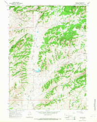 1964 Toltec1967 Print · USGSThe Laramie River high country is captured here in the mid-sixties, showing a landscape shaped by early frontier transit and mountain ranching. Trace the historic Old Fetterman Road past Toltec or locate water features like Soldier Creek Reservoir and Buck Point.2 unique versions available
 - 1981 Map of Laramie Peak
 1981 Laramie Peak1981 Print · USGSThe Laramie Mountains and Medicine Bow National Forest define this landscape in the early eighties. Genealogists and historians can trace high-country settlements like Toltec and Binford, or locate industrial sites like the Mica Mine near the North Laramie River.2 unique versions available
 - 1992 Map of Toltec, 1996 Print
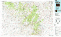
 1992 Toltec1996 Print · USGSHigh in the Wyoming mountains during the early nineties, this area was a landscape of remote ranching outposts and public forest land. Genealogists and researchers can locate the Reed Place, trace the historic Old Fort Fetterman Road, and find numerous high-country water sources like Kafko Reservoir.
 - 2012 Map of Toltec, 2012 Print
 2012 Toltec2012 Print · USGSCovers Toltec, including Squaw Place, Reed Place, and other nearby areas
 - 2015 Map of Toltec, 2015 Print
 2015 Toltec2015 Print · USGSCovers Toltec, including Squaw Place, Reed Place, and other nearby areas
 - 2017 Map of Toltec, 2017 Print
 2017 Toltec2017 Print · USGSCovers Toltec, including Squaw Place, Reed Place, and other nearby areas
 - 2021 Map of Toltec, 2021 Print
 2021 Toltec2021 Print · USGSAlbany County's high-country peaks and forest lands are captured here during the early twenty-first century. Researchers can trace historic mountain routes like Fetterman Rd and locate remote landmarks such as Fortymile Spring and Eggleston Reservoir.
End of results
Showing maps 1-9 of 9
Frequently asked questions
- What are the different types of historical maps available for Toltec?
- What is the oldest map of Toltec?
- Where can I purchase historical maps of Toltec for my home or office?
- Where can I download high-res historical maps of Toltec?
- Are there historical topographic maps available for Toltec?
- Is there historical aerial imagery available for Toltec?
- Where are historical maps of Toltec sourced from?