Old Maps of Albany County, Wyoming
Explore 606 old maps of Albany County, spanning from 1895 to today. These high-resolution historic maps reveal how streets, neighborhoods, landmarks, and natural features evolved over time — perfect for genealogy, metal detecting, research, and local history exploration.
What you can do with these maps:
- See how Albany County changed over time: Compare historical maps to modern-day views to trace roads, homesites, rail lines & more.
- View detailed metadata: Each map includes creators, publishers, year, scale, and archive source.
- Overlay maps with satellite & LiDAR: Visualize the past alongside modern tools to explore terrain & human change.
- Trusted historical sources: Maps sourced from the USGS, Library of Congress, and other archives.
- Access maps your way: View online, download high-res files, or order prints for personal or research use.
Start exploring old maps of Albany County to uncover forgotten places, hidden landmarks, and the deep history beneath your feet.
Albany County, WY maps
(606)- 1895 Map of Laramie
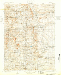
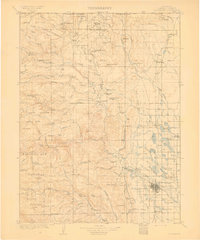
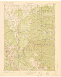
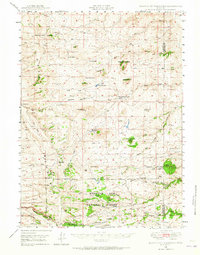
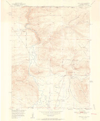
 1895 Laramie1895 Print · USGSLaramie and the high plains of Albany County are shown here in the mid-1890s, when the railroad and river systems defined the frontier. Trace the locations of early landmarks like the Penitentiary, the Sartoris Ranch, and the Union Pacific R. R. line.
 - 1902 Map of Laramie
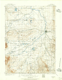
 1902 Laramie1902 Print · USGSThe high plains of Albany County come alive in this turn-of-the-century survey centered on the growing rail hub of Laramie. Genealogists and researchers can trace early homesteads and landmarks like Sartoris Ranch, Ft. Sanders, and the Union Pacific R. R. line.
 - 1905 Map of Sherman
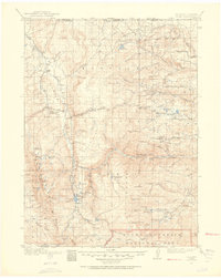
 1905 Sherman1905 Print · USGSThe Laramie foothills and high plains at the turn of the century show a landscape defined by ranching and the railroad. Researchers can trace the Union Pacific RR through old stops like Leslie or locate historic homesteads such as Bakers Ranch and Islay PO.4 unique versions available
 - 1905 Map of Laramie
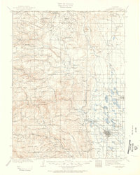
 1905 Laramie1905 Print · USGSLaramie and the high plains of southern Wyoming are shown at the height of the steam era as the railroad pushed through the basin. Genealogists can trace early railroad settlements like Colores and Red Buttes, or locate ranching landmarks such as Mandel and Huttons Grove.
 - 1906 Map of Medicine Bow, 1955 Print
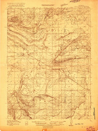
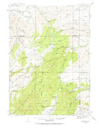
 1906 Medicine Bow1955 Print · USGSThe Medicine Bow Range at the dawn of the twentieth century shows a high-country economy driven by mining, timber, and ranching. Researchers can trace early infrastructure like the Laramie Hahns Peak and Pacific RR or locate family sites such as the Beckwith Ranch and Lenhardys Cabin.
 - 1906 Map of Laramie, 1956 Print
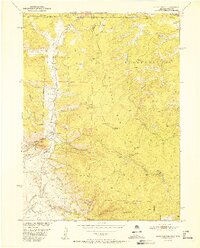
 1906 Laramie1956 Print · USGSLaramie and the surrounding high plains are captured at the turn of the century as the ranching and railroad industries matured. Researchers can locate dozens of historic family sites like Alsop's Ranch and early landmarks such as the Fish Hatchery and Leroy Bridge.
 - 1907 Map of Livermore, 1954 Print
 1907 Livermore1954 Print · USGSLarimer County at the turn of the century shows a frontier landscape transitioning into a settled ranching and rail corridor. Genealogists and historians can trace family-named sites like Maxwell Ranch alongside early landmarks like the Forks Hotel and Campbell Grove School.2 unique versions available
 - 1908 Map of Laramie
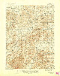
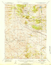
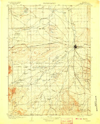 1908 Laramie1908 Print · USGSLaramie and the surrounding Albany County ranchlands are documented here at the turn of the century as the cattle industry and railroad matured. Researchers can locate early family holdings like King Ranch, the distinctive The Big Hollow, and the historic Fish Hatchery.5 unique versions available
 - 1908 Map of Medicine Bow
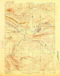
 1908 Medicine Bow1908 Print · USGSThe Medicine Bow Range at the dawn of the twentieth century shows a landscape of mountain ranches and early mining. Trace family-named landmarks like Logan-Grisley Ranch and industrial sites like Webbers Sawmill or the White Swan Mine.3 unique versions available
 - 1909 Map of Livermore
 1909 Livermore1909 Print · USGSNorthern Colorado at the turn of the century shows a landscape of developing irrigation and early mountain industry. Trace the early streets of Fort Collins or find the remote Forks Hotel and Empire Mine among the foothills.4 unique versions available
 - 1915 Map of Como Ridge
 1915 Como Ridge1915 Print · USGSThe high plains of Carbon County come alive in the early twentieth century as the legendary Lincoln Highway pushes westward alongside the Union Pacific. Genealogists and historians can trace the early development of Medicine Bow and locate rural landmarks like the Ambler School and Robbers Roost.2 unique versions available
 - 1916 Map of Home, 1954 Print
 1916 Home1954 Print · USGSHigh mountain ranching and early forestry are captured in this 1916 survey of northern Colorado as the modern park system took root. Researchers can trace historic homesteads like Williams Ranch, find the Black Mtn School, and locate the mining-era settlement of Manhattan.2 unique versions available
 - 1918 Map of Como Ridge
 1918 Como Ridge1918 Print · USGSMedicine Bow and the surrounding Carbon County high plains are captured here just before the close of the Great War. Researchers can trace the early path of the Union Pacific railroad and find rural landmarks like the Ambler School and Robbers Roost.2 unique versions available
 - 1920 Map of Home
 1920 Home1920 Print · USGSLarimer County at the end of the Great War was a landscape of high-country ranches and forest outposts. Genealogists and historians can locate family homesteads like Derby Ranch and Bennett Ranch or trace the early operations of the Black Mtn School and Manhattan.4 unique versions available
 - 1943 Map of Esterbrook, 1963 Print
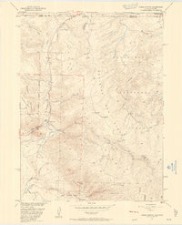
 1943 Esterbrook1963 Print · USGSThe Laramie Range high country comes into focus in the early 1940s, showing a landscape of remote mountain ranches and forest lookouts. Researchers can trace historic family holdings like La Bonte Ranch and find small rural schoolhouses such as Morton Sch and Hanks Sch.
 - 1945 Map of Esterbrook
 1945 Esterbrook1945 Print · USGSThe Converse and Albany county line in the 1940s reveals a high-plains landscape of remote mountain schools and family ranches. Genealogists can locate family landmarks like La Bonte Ranch and Morton Sch or trace the old Horseshoe Trail.2 unique versions available
 - 1948 Map of Sherman Mountains, 1958 Print
 1948 Sherman Mountains1958 Print · USGSThe high Wyoming plateau between Laramie and Cheyenne is captured here after the war, showing the legendary Lincoln Highway corridor and Medicine Bow ranching life. Researchers can trace the path of the Union Pacific through Sherman and Buford or locate historic family outposts like the K P Ranch.2 unique versions available
 - 1948 Map of Ragged Top Mountain, 1965 Print
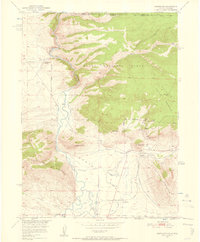
 1948 Ragged Top Mountain1965 Print · USGSAlbany County ranching and mining operations are captured here just after the war, showing a high-country network of family-owned land and federal reserves. Researchers can trace historic homesteads like Coles Ranch or locate industrial sites such as the Feldspar Strip Mine and University Quarry.2 unique versions available
 - 1950 Map of Ragged Top Mountain
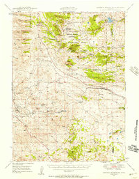
 1950 Ragged Top Mountain1950 Print · USGSHigh plains ranching and military maneuvers converge in Albany County during the mid-century, where the Medicine Bow National Forest meets the open range. Genealogists and historians can trace legacy holdings like the King Brothers Ranch or the industrial footprint of the Feldspar Strip Mine.
 - 1950 Map of Sherman Mountains
 1950 Sherman Mountains1950 Print · USGSHigh Wyoming ranching and military lands are captured here at mid-century as the Lincoln Highway and Union Pacific cross the Laramie Mountains. Genealogists can locate named homesteads like the Davis Ranch and the landmark Ames Monument.2 unique versions available
 - 1950 Map of Northgate, 1957 Print
 1950 Northgate1957 Print · USGSJackson County ranching and mining operations are captured in detail at the turn of the 1950s. Genealogists and historians can trace family-named sites like the Quaintance Ranch alongside industrial landmarks including the Fluorspar Mine and Gero Tunnel.6 unique versions available
 - 1950 Map of Kings Canyon, 1959 Print
 1950 Kings Canyon1959 Print · USGSThe Colorado-Wyoming border region in the 1950s was a hub for high-country mining and specialized irrigation. Researchers can trace historic industrial sites like the Kings Canyon Mine and water infrastructure such as the Hardwork Ditch and Government Ditch.4 unique versions available
 - 1952 Map of Northgate
 1952 Northgate1952 Print · USGSHigh-altitude ranching and mining operations meet along the North Platte River in northern Colorado during the early fifties. Genealogists and historians can trace industrial sites like the Fluorspar Mine, local landmarks like Quaintance Ranch, and the Union Pacific rail corridor.2 unique versions available
 - 1952 Map of Kings Canyon
 1952 Kings Canyon1952 Print · USGSThe Colorado-Wyoming borderlands appear here in the early fifties as a rugged high-altitude frontier shaped by mining and rail. Genealogists and historians can trace the sites of Roach and Camp Nelson along the Union Pacific line.2 unique versions available
 - 1954 Map of Torrington, 1963 Print
 1954 Torrington1963 Print · USGSEastern Wyoming and the Nebraska borderlands are captured here during the mid-fifties, showing a landscape shaped by the Platte River and the Laramie Range. Researchers can trace deep history at the Fort Laramie National Historical Site, the Old Doty Ranch Site, and along the Old Fetterman Road.4 unique versions available
Showing maps 1-25 of 606
Top cities of Albany County
Frequently asked questions
- What are the different types of historical maps available for Albany County?
- What is the oldest map of Albany County?
- Where can I purchase historical maps of Albany County for my home or office?
- Where can I download high-res historical maps of Albany County?
- Are there historical topographic maps available for Albany County?
- Is there historical aerial imagery available for Albany County?
- Where are historical maps of Albany County sourced from?