2020s Maps of Albany County, Wyoming
Explore 104 historic maps of Albany County from the 2020s. These maps offer a rare glimpse into what life looked like during the 2020s — showing old roads, neighborhoods, homes, and landmarks that have changed or disappeared over time.
Whether you're researching your family's past, planning a metal detecting trip, or studying how Albany County's landscape evolved across the 2020s, these high-resolution maps are a powerful tool for exploring the history of this region.
- Focus on a specific era: All maps on this page are from the 2020s, giving you a focused view of this time period.
- See what’s changed: Compare century-old streets, trails, and buildings to today's modern landscape using overlays and satellite layers.
- Research with precision: Use these maps for genealogy, historical research, land use analysis, or educational projects.
- View, download, or print: Maps are fully viewable online in high resolution, and can be downloaded or printed for your own records.
Start exploring Albany County's history through authentic maps from the 2020s. This is your window into the past.
Albany County, WY maps
(104)- 2021 Map of Wilcox, 2021 Print
 2021 Wilcox2021 Print · USGSThe northern edge of Rock River and the settlement of Wilcox appear here in the early twenty-first century. Genealogists and researchers can trace local ranching boundaries and water systems along Rock Creek, Taylor Ditch, and Johnston Ditch.
 - 2021 Map of Downey Lakes, 2021 Print
 2021 Downey Lakes2021 Print · USGSThe ranching country of Albany County is captured here in the early twenty-first century, showcasing a landscape shaped by water rights and irrigation. Researchers can trace historic water management systems like Old King Ditch, Lone Tree Ditch, and Davis Brothers Ditch Number 1.
 - 2021 Map of Dodge Ranch, 2021 Print
 2021 Dodge Ranch2021 Print · USGSThis high-plains landscape in Albany County captures a 2021 view of Wyoming's vital water management and ranching tradition. Trace the path of the Laramie River and explore local landmarks like Dodge Ranch, Wheatland Reservoir Number Two, and Long Canyon.
 - 2021 Map of Big Judson, 2021 Print
 2021 Big Judson2021 Print · USGSBig Judson and the surrounding Wyoming plains are captured in this recent survey of Albany County. Researchers can trace the sophisticated network of irrigation canals and natural waterways, including King Ditch Number 2, Cavender Reservoir, and Cooper Cr.
 - 2021 Map of Laramie SW, 2021 Print
 2021 Laramie SW2021 Print · USGSThe Albany County landscape southwest of Laramie comes into focus in this recent survey, showing the expansion of irrigation and aviation. Genealogists and local historians can trace the Harmony Cem, the winding Pioneer Canal, and the unique geography of The Big Hollow.
 - 2021 Map of Pine Tree Ridge, 2021 Print
 2021 Pine Tree Ridge2021 Print · USGSThe high plains of Albany County are documented here in the early twenty-first century, showcasing a landscape defined by intermittent water and open range. Researchers can trace the winding path of Rock Creek and locate vital water sources like Soda Lake and Mud Springs.
 - 2021 Map of Best Ranch, 2021 Print
 2021 Best Ranch2021 Print · USGSAlbany County ranching and mountain terrain are captured in this recent survey of the Laramie Range foothills. Genealogists and local historians can trace family sites at Tie Siding and its Tie Siding Cem, or locate landmarks like Best Ranch and Dirty Woman Draw.
 - 2021 Map of Howell, 2021 Print
 2021 Howell2021 Print · USGSThe Albany County ranching country north of Laramie comes into focus in the early 2020s, centered on the settlement of Howell. Genealogists and historians can trace the irrigation network of the Pioneer Canal and land features like Old Smuggler Reservoir and Roger Canyon.
 - 2021 Map of Bull Camp Peak, 2021 Print
 2021 Bull Camp Peak2021 Print · USGSHigh-altitude ranching country in Albany County is documented here during the early twenty-first century. Researchers can trace the path of the Wheatland Tunnel and find family-named landmarks like Douthitt Mtn, Elmers Rock, and the Laramie River.
 - 2021 Map of Goat Mountain, 2021 Print
 2021 Goat Mountain2021 Print · USGSThe high Wyoming plains along the Albany and Laramie county line are shown here in modern detail. Researchers can trace the drainage of Middle Chugwater Cr and locate high-altitude landmarks like Goat Mtn and Limestone Rim.
 - 2021 Map of Lake Ione, 2021 Print
 2021 Lake Ione2021 Print · USGSAlbany County's high plains irrigation network is fully detailed in this recent survey of the Laramie River basin. Local historians can trace the historic Old Fort Fetterman Rd and the complex water systems of Lake Ione, Boughton Canal, and Long Lake.
 - 2021 Map of Guide Rock, 2021 Print
 2021 Guide Rock2021 Print · USGSThe Laramie Mountains high country in Albany County is captured here in the early twenty-first century. Researchers can trace the drainage of Halleck Canyon and locate remote landmarks like Guide Rock and Tower Canyon among the high ridges.
 - 2021 Map of McGill Lakes, 2021 Print
 2021 McGill Lakes2021 Print · USGSAlbany County ranchlands and water systems are documented in this 2021 survey of the Laramie River basin. Trace the path of Old Fort Fetterman Rd past McGill Lakes, Post Lake, and the crossing at McGill Bridge.
 - 2021 Map of Sand Lake, 2021 Print
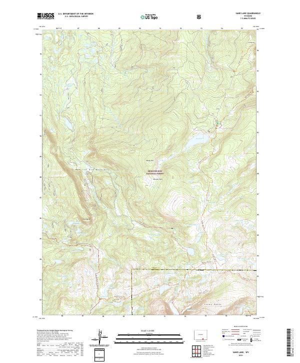 2021 Sand Lake2021 Print · USGSThe high alpine country of Carbon County comes into focus in the early twenty-first century as it spans the heights of the Medicine Bow Mountains. Researchers can trace the legacy of back-country travel along the Sheep Lake Trl or locate landmarks like Stillwater Park and Drillers Lake.
 - 2021 Map of Centennial, 2021 Print
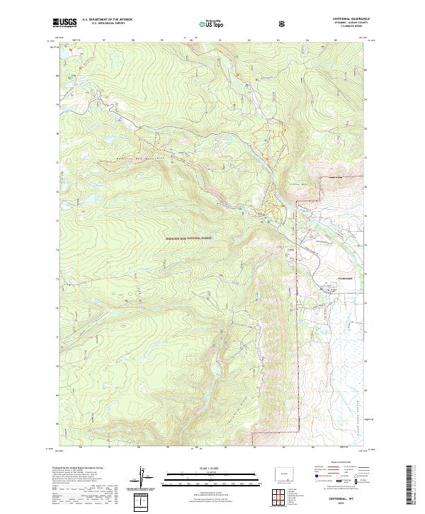 2021 Centennial2021 Print · USGSCentennial and the surrounding high country of the Medicine Bow Mountains appear here in the early twenty-first century. Researchers can trace the complex irrigation network of Adams Ditch or explore the many trails surrounding Corner Mtn and Little Brooklyn Lake.
 - 2021 Map of Bosler SE, 2021 Print
 2021 Bosler SE2021 Print · USGSHigh plains ranching and the ascent of the Laramie Mountains characterize this Albany County landscape in the early 2020s. Trace the winding paths of Middle Creek Ranch Rd and Pascoe Ranch Rd as they follow Wallrock Cr through the foothills.
 - 2021 Map of James Lake, 2021 Print
 2021 James Lake2021 Print · USGSAlbany County ranching country is shown here in the 2020s, revealing the intricate water systems that define the high plains. Researchers can trace historic irrigation lines like Battin Ditch and Bellamy Ditch alongside landmarks like Sevenmile Hill.
 - 2021 Map of Bosler, 2021 Print
 2021 Bosler2021 Print · USGSThe Laramie Plains of Albany County come into focus during the early twenty-first century, centered on the settlement of Bosler. Researchers can trace the legacy of high-plains ranching through the Laramie River corridor and irrigation features like Boughton Canal and Oasis Ditch.
 - 2021 Map of Bluegrass Wells, 2021 Print
 2021 Bluegrass Wells2021 Print · USGSHigh-plains ranching country in Albany County is documented here during the early twenty-first century. Researchers can trace the essential water sources of the region, from the wide Wheatland Reservoir Number Two to the central Bluegrass Wells and West Bluegrass Creek.
 - 2021 Map of Cooper Lake North, 2021 Print
 2021 Cooper Lake North2021 Print · USGSAlbany County's high-plains ranching country is documented here in the early twenty-first century as the railroad and highway cross the basin. Local historians can trace the transit corridor through Lookout and identify water features like Cavender Reservoir and Cooper Lake.
 - 2021 Map of Sybille Springs, 2021 Print
 2021 Sybille Springs2021 Print · USGSWyoming's high-country transition between the plains and the Laramie Mountains comes into focus in this recent survey. Trace the historic route of Old Fort Fetterman Rd past Sybille Springs and through the gap at Morton Pass.
 - 2021 Map of Rex Lake, 2021 Print
 2021 Rex Lake2021 Print · USGSAlbany County ranching and forest lands are captured in this recent survey, showing the transition from mountain peaks to the valley floor. Researchers can trace the extensive irrigation network through Bellamy Ditch and Adams Ditch near Rex Lake.
 - 2021 Map of Millbrook, 2021 Print
 2021 Millbrook2021 Print · USGSThe high ranchlands of Albany County come into focus in this recent survey of the Hatton area. Researchers can trace the sophisticated irrigation networks of the Little Laramie River and explore named sites like Swedes Cabin Lake and Table Mtn.
 - 2021 Map of Dale Creek, 2021 Print
 2021 Dale Creek2021 Print · USGSAlbany County's high-altitude ranching country is captured here in the contemporary era, centered on the vital rail crossing at the Hermosa Tunnel. Local historians can trace the paths of the Old Wagon Rd and locate landmarks like the Natural Ft and Hermosa.
 - 2021 Map of Red Buttes, 2021 Print
 2021 Red Buttes2021 Print · USGSAlbany County enters the 2020s as a landscape of managed water and high-plains geology. Researchers can trace the legacy of early ranching and land use through Red Buttes, the waters of Leazenby Lake, and the winding Harney Cr.
Showing maps 1-25 of 104
Top cities of Albany County
Frequently asked questions
- What are the different types of historical maps available for Albany County?
- What is the oldest map of Albany County?
- Where can I purchase historical maps of Albany County for my home or office?
- Where can I download high-res historical maps of Albany County?
- Are there historical topographic maps available for Albany County?
- Is there historical aerial imagery available for Albany County?
- Where are historical maps of Albany County sourced from?