1900-1909 Maps of Albany County, Wyoming
Explore 9 historic maps of Albany County from 1900-1909. These maps offer a rare glimpse into what life looked like during the 1900s — showing old roads, neighborhoods, homes, and landmarks that have changed or disappeared over time.
Whether you're researching your family's past, planning a metal detecting trip, or studying how Albany County's landscape evolved across the 1900s, these high-resolution maps are a powerful tool for exploring the history of this region.
- Focus on a specific era: All maps on this page are from the 1900s, giving you a focused view of this time period.
- See what’s changed: Compare century-old streets, trails, and buildings to today's modern landscape using overlays and satellite layers.
- Research with precision: Use these maps for genealogy, historical research, land use analysis, or educational projects.
- View, download, or print: Maps are fully viewable online in high resolution, and can be downloaded or printed for your own records.
Start exploring Albany County's history through authentic maps from the 1900s. This is your window into the past.
Albany County, WY maps
(9)- 1902 Map of Laramie
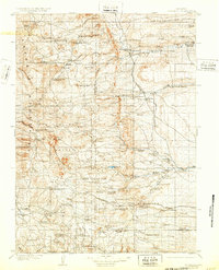
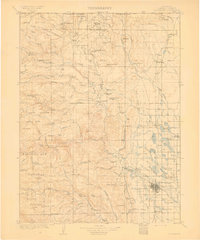
 1902 Laramie1902 Print · USGSThe high plains of Albany County come alive in this turn-of-the-century survey centered on the growing rail hub of Laramie. Genealogists and researchers can trace early homesteads and landmarks like Sartoris Ranch, Ft. Sanders, and the Union Pacific R. R. line.
 - 1905 Map of Sherman
 1905 Sherman1905 Print · USGSThe Laramie foothills and high plains at the turn of the century show a landscape defined by ranching and the railroad. Researchers can trace the Union Pacific RR through old stops like Leslie or locate historic homesteads such as Bakers Ranch and Islay PO.4 unique versions available
 - 1905 Map of Laramie
 1905 Laramie1905 Print · USGSLaramie and the high plains of southern Wyoming are shown at the height of the steam era as the railroad pushed through the basin. Genealogists can trace early railroad settlements like Colores and Red Buttes, or locate ranching landmarks such as Mandel and Huttons Grove.
 - 1906 Map of Medicine Bow, 1955 Print
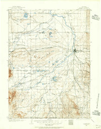
 1906 Medicine Bow1955 Print · USGSThe Medicine Bow Range at the dawn of the twentieth century shows a high-country economy driven by mining, timber, and ranching. Researchers can trace early infrastructure like the Laramie Hahns Peak and Pacific RR or locate family sites such as the Beckwith Ranch and Lenhardys Cabin.
 - 1906 Map of Laramie, 1956 Print
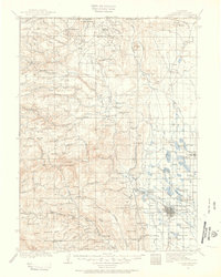
 1906 Laramie1956 Print · USGSLaramie and the surrounding high plains are captured at the turn of the century as the ranching and railroad industries matured. Researchers can locate dozens of historic family sites like Alsop's Ranch and early landmarks such as the Fish Hatchery and Leroy Bridge.
 - 1907 Map of Livermore, 1954 Print
 1907 Livermore1954 Print · USGSLarimer County at the turn of the century shows a frontier landscape transitioning into a settled ranching and rail corridor. Genealogists and historians can trace family-named sites like Maxwell Ranch alongside early landmarks like the Forks Hotel and Campbell Grove School.2 unique versions available
 - 1908 Map of Laramie
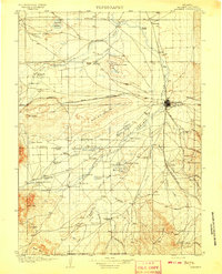 1908 Laramie1908 Print · USGSLaramie and the surrounding Albany County ranchlands are documented here at the turn of the century as the cattle industry and railroad matured. Researchers can locate early family holdings like King Ranch, the distinctive The Big Hollow, and the historic Fish Hatchery.5 unique versions available
 - 1908 Map of Medicine Bow
 1908 Medicine Bow1908 Print · USGSThe Medicine Bow Range at the dawn of the twentieth century shows a landscape of mountain ranches and early mining. Trace family-named landmarks like Logan-Grisley Ranch and industrial sites like Webbers Sawmill or the White Swan Mine.3 unique versions available
 - 1909 Map of Livermore
 1909 Livermore1909 Print · USGSNorthern Colorado at the turn of the century shows a landscape of developing irrigation and early mountain industry. Trace the early streets of Fort Collins or find the remote Forks Hotel and Empire Mine among the foothills.4 unique versions available
End of results
Showing maps 1-9 of 9
Top cities of Albany County
Frequently asked questions
- What are the different types of historical maps available for Albany County?
- What is the oldest map of Albany County?
- Where can I purchase historical maps of Albany County for my home or office?
- Where can I download high-res historical maps of Albany County?
- Are there historical topographic maps available for Albany County?
- Is there historical aerial imagery available for Albany County?
- Where are historical maps of Albany County sourced from?