Old Maps of Moorcroft, Wyoming for Metal Detecting
Plan your next treasure hunt with 12 historic maps of Moorcroft. Find old homesites, ghost towns, trails, and gathering spots that may be lost to time — perfect for identifying promising metal detecting locations.
- Locate forgotten sites: Uncover places like long-lost settlements, abandoned rail lines, or gathering spots.
- Plan better hunts: Use map overlays combined with LiDAR or satellite views to narrow in on historically rich areas.
- Made for detectorists: Thousands of hobbyists use these maps to discover relics, coins, and hidden history.
Use these historic maps to boost your research and find new opportunities beneath the surface of Moorcroft.
Moorcroft, WY maps
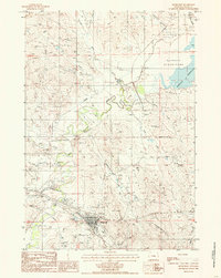
(12)- 1918 Map of Moorcroft
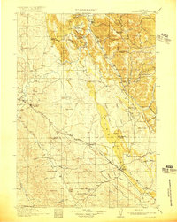 1918 Moorcroft1918 Print · USGSNortheastern Wyoming’s ranching and railroad landscape is captured here just before the end of the Great War. Genealogists can locate nearly twenty rural schoolhouses, including the Dakota Ridge School, while following the Chicago Burlington and Quincy rail line through Thornton and Upton.2 unique versions available
 - 1918 Map of Moorcroft, 1941 Print
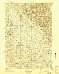 1918 Moorcroft1941 Print · USGSNortheastern Wyoming's ranching and rail landscape comes alive in this survey of the high plains just after the First World War. Genealogists and local historians can locate early country schools like Ely School and Marsh School along the Chicago Burlington and Quincy Railroad.
 - 1954 Map of Gillette, 1975 Print
 1954 Gillette1975 Print · USGSGillette and the northeast Wyoming ranching country are captured here in the mid-1950s as coal and bentonite mining shaped the local economy. Genealogists can trace family landmarks like the Bethlehem Church, Wellman School, and early settlements along the Chicago Burlington and Quincy RR.
 - 1955 Map of Gillette, 1976 Print
 1955 Gillette1976 Print · USGSNortheastern Wyoming in the mid-twentieth century is captured here as the energy and ranching landscape began to shift. Genealogists and historians can trace the foundations of local communities through sites like Wyodak, the Pleasantdale Community Building, and landmarks like Devils Tower National Monument.
 - 1957 Map of Moorcroft, 1959 Print
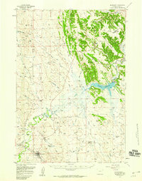 1957 Moorcroft1959 Print · USGSThe cattle and rail hub of Moorcroft is captured here in the late fifties, just as the regional landscape was transformed by the Keyhole Reservoir. Genealogists and historians can trace old ranch boundaries like the Robinson Ranch or locate local landmarks including the Texas Trail and Thorn Divide School.3 unique versions available
 - 1958 Map of Gillette
 1958 Gillette1958 Print · USGSNortheastern Wyoming and the Black Hills are captured here in the late fifties, showcasing a landscape of high-plains ranching and emerging energy production. Researchers can trace the rail-side growth of Gillette and find historic rural landmarks like the Wyodak Coal Mine, Bethlehem Church, and Devils Tower National Monument.2 unique versions available
 - 1962 Map of Gillette
 1962 Gillette1962 Print · USGSHigh plains ranching and coal mining dominate the Powder River Basin in the early sixties. Genealogists can trace rural communities through landmarks like the Bethlehem Church, Lake School, and settlements such as Moorcroft and Sundance.
 - 1979 Map of Sundance
 1979 Sundance1979 Print · USGSThe Black Hills borderlands in the late 1970s show a region of high peaks and vital rail corridors connecting Wyoming to South Dakota. Researchers can trace historic routes and industry through settlements like Clay Spur, Upton, and the Historical Monument.2 unique versions available
 - 1984 Map of Grasshopper Butte, 1985 Print
 1984 Grasshopper Butte1985 Print · USGSCrook County, Wyoming, is captured in the mid-1980s as the landscape balances recreation at Keyhole Reservoir with active mining operations. Genealogists and researchers can trace local landmarks like Grasshopper Butte and numerous Bentonite Pits near Mule Creek.
 - 1984 Map of Moorcroft, 1985 Print
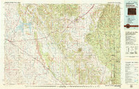
 1984 Moorcroft1985 Print · USGSMoorcroft and the surrounding Crook County ranchlands are documented here in the early 1980s as the regional energy economy expanded. Researchers can trace the town's growth near Donkey Creek, the local Cem, and the industrial footprint of the Oil Field.
 - 2021 Map of Grasshopper Butte, 2021 Print
 2021 Grasshopper Butte2021 Print · USGSCrook County at the start of the 2020s shows the development of recreation and transport hubs near the Keyhole Reservoir shoreline. Researchers can trace local landmarks like Pine Haven Cem, the residential growth at Lower Pine Ridge, and prominent heights such as Grasshopper Butte.
 - 2021 Map of Moorcroft, 2021 Print
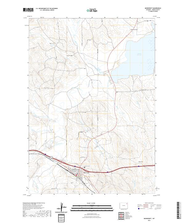 2021 Moorcroft2021 Print · USGSMoorcroft and the eastern plains of Wyoming are documented here in the modern era, showing the town at a major crossroads. Genealogists and local historians can trace family plots at the Moorcroft Cem and explore the banks of the Belle Fourche River and Keyhole Reservoir.
End of results
Showing maps 1-12 of 12
Top cities near Moorcroft
Frequently asked questions
- What are the different types of historical maps available for Moorcroft?
- What is the oldest map of Moorcroft?
- Where can I purchase historical maps of Moorcroft for my home or office?
- Where can I download high-res historical maps of Moorcroft?
- Are there historical topographic maps available for Moorcroft?
- Is there historical aerial imagery available for Moorcroft?
- Where are historical maps of Moorcroft sourced from?