1900s (20th Century) Maps of Kirby, Wyoming
Explore 7 historic maps of Kirby from the 1900s (20th Century). These maps offer a rare glimpse into what life looked like during the 1900s — showing old roads, neighborhoods, homes, and landmarks that have changed or disappeared over time.
Whether you're researching your family's past, planning a metal detecting trip, or studying how Kirby's landscape evolved across the 1900s, these high-resolution maps are a powerful tool for exploring the history of this region.
- Focus on a specific era: All maps on this page are from the 1900s, giving you a focused view of this time period.
- See what’s changed: Compare century-old streets, trails, and buildings to today's modern landscape using overlays and satellite layers.
- Research with precision: Use these maps for genealogy, historical research, land use analysis, or educational projects.
- View, download, or print: Maps are fully viewable online in high resolution, and can be downloaded or printed for your own records.
Start exploring Kirby's history through authentic maps from the 1900s. This is your window into the past.
Kirby, WY maps
(7)- 1945 Map of Kirby, 1958 Print
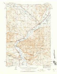 1945 Kirby1958 Print · USGSThe Bighorn River valley in the mid-1940s shows a region transitioning from its peak coal-mining years. Genealogists and historians can trace defunct operations like Crosby Mine, rail stops at Chatham Sta, and old frontier landmarks like The Willows (Old Stage Sta).2 unique versions available
 - 1946 Map of Kirby
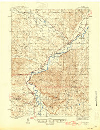 1946 Kirby1946 Print · USGSThe Bighorn River valley in the mid-1940s reveals a transition from active coal extraction to a rail-and-ranching economy. Researchers can locate the remnants of the Crosby Mine, the site of The Willows (Old Stage Sta), and the settlement of Gebo.
 - 1955 Map of Thermopolis, 1969 Print
 1955 Thermopolis1969 Print · USGSMid-century Wyoming comes alive in this survey of the Wind River basin and the high Absaroka peaks. Trace the roots of oil and water development through the Hamilton Dome Oil Field and the Boysen Reservoir, or locate local landmarks like the Wyoming Industrial Institute and St. Stephens.2 unique versions available
 - 1958 Map of Thermopolis
 1958 Thermopolis1958 Print · USGSThe Bighorn Basin and Wind River Reservation are shown here in the late fifties, during a period of significant petroleum and agricultural growth. Genealogists and historians can trace rail-towns like Gebo, energy hubs like the Hamilton Dome Oil Field, and the layout of Fort Washakie.2 unique versions available
 - 1962 Map of Thermopolis
 1962 Thermopolis1962 Print · USGSThe Wind River and Bighorn basins are meticulously mapped in the early sixties, showing the vital irrigation and rail networks of the era. Genealogists and historians can locate specific landmarks like the Duncan Ranch School, the Wyoming Industrial Institute, and the Hamilton Dome oil field.
 - 1981 Map of Thermopolis, 1982 Print
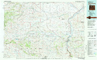 1981 Thermopolis1982 Print · USGSCentral Wyoming in the early eighties shows a landscape of geothermal wonders and energy extraction. Trace the legacy of early settlements and industry near Hot Springs State Park, the rail lines of the Burlington Northern, and outposts like Gebo and Hamilton Dome.
 - 1985 Map of Kirby
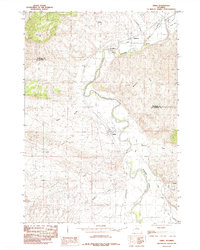 1985 Kirby1985 Print · USGSThe Bighorn River valley in the mid-1980s reveals a landscape shaped by irrigation and early industry. Trace the reach of the Hanover Canal and explore the historic settlements of Gebo and Kirby as they appeared forty years ago.
End of results
Showing maps 1-7 of 7
Top cities near Kirby
Frequently asked questions
- What are the different types of historical maps available for Kirby?
- What is the oldest map of Kirby?
- Where can I purchase historical maps of Kirby for my home or office?
- Where can I download high-res historical maps of Kirby?
- Are there historical topographic maps available for Kirby?
- Is there historical aerial imagery available for Kirby?
- Where are historical maps of Kirby sourced from?