1900s (20th Century) Maps of Carpenter, Wyoming
Explore 5 historic maps of Carpenter from the 1900s (20th Century). These maps offer a rare glimpse into what life looked like during the 1900s — showing old roads, neighborhoods, homes, and landmarks that have changed or disappeared over time.
Whether you're researching your family's past, planning a metal detecting trip, or studying how Carpenter's landscape evolved across the 1900s, these high-resolution maps are a powerful tool for exploring the history of this region.
- Focus on a specific era: All maps on this page are from the 1900s, giving you a focused view of this time period.
- See what’s changed: Compare century-old streets, trails, and buildings to today's modern landscape using overlays and satellite layers.
- Research with precision: Use these maps for genealogy, historical research, land use analysis, or educational projects.
- View, download, or print: Maps are fully viewable online in high resolution, and can be downloaded or printed for your own records.
Start exploring Carpenter's history through authentic maps from the 1900s. This is your window into the past.
Carpenter, WY maps
(5)- 1954 Map of Cheyenne, 1963 Print
 1954 Cheyenne1963 Print · USGSSoutheastern Wyoming's high plains and the capital city's mid-century expansion are documented here during the early Cold War. Genealogists and historians can trace rail-aligned settlements like Pine Bluffs and Hillsdale, or explore landmarks like the Ames Monument and Francis E. Warren Air Force Base.3 unique versions available
 - 1958 Map of Cheyenne
 1958 Cheyenne1958 Print · USGSSoutheast Wyoming and the Nebraska border appear in the late 1950s as a hub of military defense and rail commerce. Genealogists can trace the Union Pacific through Cheyenne or locate the Horse Creek Oil Field and the State Capitol.2 unique versions available
 - 1963 Map of Carpenter, 1967 Print
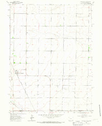 1963 Carpenter1967 Print · USGSThe high plains borderland between Wyoming and Colorado comes into focus in the early sixties, showing the rail-dependent town of Carpenter. Genealogists and local historians can trace the Chicago Burlington and Quincy railroad and the local Cem.
 - 1981 Map of Cheyenne
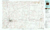 1981 Cheyenne1981 Print · USGSCheyenne and the surrounding high plains are captured here in the early eighties, showcasing the intersection of major rail lines and interstate highways. Genealogists and historians can trace the development of outlying ranching communities like Carpenter, Arcola, and the border town of Pine Bluffs.2 unique versions available
 - 1991 Map of Carpenter, 1995 Print
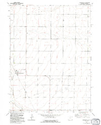 1991 Carpenter1995 Print · USGSNear the Wyoming-Colorado border in the early nineties, the small community of Carpenter remained a quiet agricultural hub. Local historians can trace the remnants of the Old Railroad Grade and locate family markers at the village Cem.
End of results
Showing maps 1-5 of 5
Top cities near Carpenter
Frequently asked questions
- What are the different types of historical maps available for Carpenter?
- What is the oldest map of Carpenter?
- Where can I purchase historical maps of Carpenter for my home or office?
- Where can I download high-res historical maps of Carpenter?
- Are there historical topographic maps available for Carpenter?
- Is there historical aerial imagery available for Carpenter?
- Where are historical maps of Carpenter sourced from?