1960s Maps of Orchard Valley, Laramie County
Explore 2 historic maps of Orchard Valley from the 1960s. These maps offer a rare glimpse into what life looked like during the 1960s — showing old roads, neighborhoods, homes, and landmarks that have changed or disappeared over time.
Whether you're researching your family's past, planning a metal detecting trip, or studying how Orchard Valley's landscape evolved across the 1960s, these high-resolution maps are a powerful tool for exploring the history of this region.
- Focus on a specific era: All maps on this page are from the 1960s, giving you a focused view of this time period.
- See what’s changed: Compare century-old streets, trails, and buildings to today's modern landscape using overlays and satellite layers.
- Research with precision: Use these maps for genealogy, historical research, land use analysis, or educational projects.
- View, download, or print: Maps are fully viewable online in high resolution, and can be downloaded or printed for your own records.
Start exploring Orchard Valley's history through authentic maps from the 1960s. This is your window into the past.
Orchard Valley, Laramie County maps
(2)- 1961 Map of Cheyenne South, 1963 Print
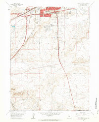 1961 Cheyenne South1963 Print · USGSThe southern outskirts of Cheyenne in the early sixties reveal a landscape of emerging neighborhoods and essential rail hubs. Genealogists and historians can trace the foundations of Orchard Valley and locate landmarks like the Full Gospel Tabernacle and Intermountain Speedway.3 unique versions available
 - 1961 Map of Cheyenne, 1964 Print
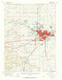 1961 Cheyenne1964 Print · USGSCheyenne and its surrounding high plains are captured here in the early sixties, showing a period of significant military and rail infrastructure. Genealogists and historians can locate old landmarks like Lakeview Cem, the USDA Horticultural Field Station, and early settlements such as Borie and Speer.
End of results
Showing maps 1-2 of 2
Frequently asked questions
- What are the different types of historical maps available for Orchard Valley?
- What is the oldest map of Orchard Valley?
- Where can I purchase historical maps of Orchard Valley for my home or office?
- Where can I download high-res historical maps of Orchard Valley?
- Are there historical topographic maps available for Orchard Valley?
- Is there historical aerial imagery available for Orchard Valley?
- Where are historical maps of Orchard Valley sourced from?