1900s (20th Century) Maps of Edgerton, Wyoming
Explore 7 historic maps of Edgerton from the 1900s (20th Century). These maps offer a rare glimpse into what life looked like during the 1900s — showing old roads, neighborhoods, homes, and landmarks that have changed or disappeared over time.
Whether you're researching your family's past, planning a metal detecting trip, or studying how Edgerton's landscape evolved across the 1900s, these high-resolution maps are a powerful tool for exploring the history of this region.
- Focus on a specific era: All maps on this page are from the 1900s, giving you a focused view of this time period.
- See what’s changed: Compare century-old streets, trails, and buildings to today's modern landscape using overlays and satellite layers.
- Research with precision: Use these maps for genealogy, historical research, land use analysis, or educational projects.
- View, download, or print: Maps are fully viewable online in high resolution, and can be downloaded or printed for your own records.
Start exploring Edgerton's history through authentic maps from the 1900s. This is your window into the past.
Edgerton, WY maps
(7)- 1955 Map of Arminto, 1976 Print
 1955 Arminto1976 Print · USGSCentral Wyoming at the mid-century shows a landscape of energy reserves and high-plains ranching. Genealogists and historians can trace the Burlington Northern line through Lost Cabin and the famed Teapot Dome Naval Petroleum Reserve No 3.2 unique versions available
 - 1958 Map of Arminto
 1958 Arminto1958 Print · USGSCentral Wyoming in the late fifties was a landscape of high-plains energy and remote rail outposts. Researchers can trace the Chicago Burlington and Quincy railroad through towns like Arminto and Waltman or locate landmarks like Teapot Rock.
 - 1959 Map of Edgerton, 1962 Print
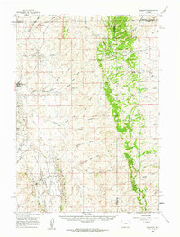 1959 Edgerton1962 Print · USGSHigh plains oil production and ranching define this Wyoming landscape during the late fifties. Researchers can trace the boundaries of the Teapot Dome Naval Petroleum Reserve No 3 and locate sites like Parsons Ranch and the Sawmill near Pine Ridge.
 - 1962 Map of Arminto
 1962 Arminto1962 Print · USGSCentral Wyoming in the early sixties reveals a landscape shaped by the Chicago and North Western railroad and early energy development. Trace the history of the region through remote outposts like Arminto, the US Naval Petroleum Reserve, and the geologic landmark at Hells Half Acre.
 - 1968 Map of Midwest, 1972 Print
 1968 Midwest1972 Print · USGSMidwest and Edgerton are captured here in the late sixties as bustling hubs of the Wyoming energy landscape. Genealogists and historians can trace the industrial footprint of the Shannon Pool Oil Field alongside local landmarks like Midwest Cem and the Gas Plant Camp.2 unique versions available
 - 1981 Map of Midwest
 1981 Midwest1981 Print · USGSThe energy-rich plains of central Wyoming are mapped here during the early eighties, highlighting the massive Salt Creek Oil Field. Local historians can trace the rail lines of the Burlington Northern Railroad and locate landmarks like Teapot Rock and the town of Midwest.
 - 1984 Map of Edgerton
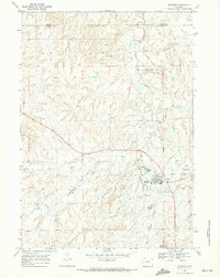
 1984 Edgerton1984 Print · USGSThe high plains of Natrona County come into focus in the 1980s, centered on the settlement of Edgerton. Researchers can trace the complex network of arid-land drainage systems like Coal Draw, Dead Ford Draw, and the meandering Salt Creek.
End of results
Showing maps 1-7 of 7
Top cities near Edgerton
Frequently asked questions
- What are the different types of historical maps available for Edgerton?
- What is the oldest map of Edgerton?
- Where can I purchase historical maps of Edgerton for my home or office?
- Where can I download high-res historical maps of Edgerton?
- Are there historical topographic maps available for Edgerton?
- Is there historical aerial imagery available for Edgerton?
- Where are historical maps of Edgerton sourced from?