1980s Maps of Tower Junction, Wyoming
Explore 2 historic maps of Tower Junction from the 1980s. These maps offer a rare glimpse into what life looked like during the 1980s — showing old roads, neighborhoods, homes, and landmarks that have changed or disappeared over time.
Whether you're researching your family's past, planning a metal detecting trip, or studying how Tower Junction's landscape evolved across the 1980s, these high-resolution maps are a powerful tool for exploring the history of this region.
- Focus on a specific era: All maps on this page are from the 1980s, giving you a focused view of this time period.
- See what’s changed: Compare century-old streets, trails, and buildings to today's modern landscape using overlays and satellite layers.
- Research with precision: Use these maps for genealogy, historical research, land use analysis, or educational projects.
- View, download, or print: Maps are fully viewable online in high resolution, and can be downloaded or printed for your own records.
Start exploring Tower Junction's history through authentic maps from the 1980s. This is your window into the past.
Tower Junction, WY maps
(2)- 1983 Map of Yellowstone National Park North
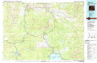 1983 Yellowstone National Park North1983 Print · USGSThe northern wilderness of Wyoming and Montana is captured here in the early eighties, documenting the geothermal landmarks and early visitor infrastructure. Trace the historic paths of the Howard Eaton Trail or locate park icons like Mammoth Hot Springs and the Lake Hotel.
 - 1986 Map of Tower Junction
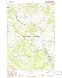 1986 Tower Junction1986 Print · USGSUpper Yellowstone Park in the mid-1980s reveals a wilderness of thermal springs and early backcountry routes. Trace historic locations like Yanceys and Tower Junction alongside natural wonders including Tower Fall and the Petrified Tree.2 unique versions available
End of results
Showing maps 1-2 of 2
Frequently asked questions
- What are the different types of historical maps available for Tower Junction?
- What is the oldest map of Tower Junction?
- Where can I purchase historical maps of Tower Junction for my home or office?
- Where can I download high-res historical maps of Tower Junction?
- Are there historical topographic maps available for Tower Junction?
- Is there historical aerial imagery available for Tower Junction?
- Where are historical maps of Tower Junction sourced from?