1960s Maps of Glendo, Wyoming
Explore 2 historic maps of Glendo from the 1960s. These maps offer a rare glimpse into what life looked like during the 1960s — showing old roads, neighborhoods, homes, and landmarks that have changed or disappeared over time.
Whether you're researching your family's past, planning a metal detecting trip, or studying how Glendo's landscape evolved across the 1960s, these high-resolution maps are a powerful tool for exploring the history of this region.
- Focus on a specific era: All maps on this page are from the 1960s, giving you a focused view of this time period.
- See what’s changed: Compare century-old streets, trails, and buildings to today's modern landscape using overlays and satellite layers.
- Research with precision: Use these maps for genealogy, historical research, land use analysis, or educational projects.
- View, download, or print: Maps are fully viewable online in high resolution, and can be downloaded or printed for your own records.
Start exploring Glendo's history through authentic maps from the 1960s. This is your window into the past.
Glendo, WY maps
(2)- 1961 Map of Glendo, 1965 Print
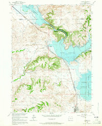 1961 Glendo1965 Print · USGSEastern Wyoming in the early sixties shows a landscape transformed by the Glendo Reservoir and the Chicago Burlington and Quincy rail line. Researchers can find the town of Glendo and remote landmarks like Buffalo Springs and Red Canyon.3 unique versions available
 - 1961 Map of Sibley Peak, 1965 Print
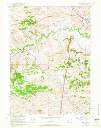 1961 Sibley Peak1965 Print · USGSThe High Plains of Platte County come alive in this early sixties survey, where the path of the Emigrant Trail meets modern rails. Researchers can locate the Pony Express Sta, the Horseshoe Cem, and family landmarks like Sommers Hill.2 unique versions available
End of results
Showing maps 1-2 of 2
Frequently asked questions
- What are the different types of historical maps available for Glendo?
- What is the oldest map of Glendo?
- Where can I purchase historical maps of Glendo for my home or office?
- Where can I download high-res historical maps of Glendo?
- Are there historical topographic maps available for Glendo?
- Is there historical aerial imagery available for Glendo?
- Where are historical maps of Glendo sourced from?