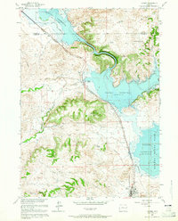
1961 Map of Glendo
USGS Topo · Published 1965About this map
The North Platte River defines the landscape of this 1961 Wyoming survey, showing the transformative impact of the Glendo Reservoir. Managed as part of the Missouri River Basin development program, the reservoir is framed by the Glendo State Park and the rugged topography of the Grey Hills and Red Canyon. The town of Glendo sits at the southwestern edge of the sheet, served by the Chicago Burlington and Quincy railroad, which parallels the shoreline. A series of quarries and a Gravel Pit indicate the local industrial activity tied to the region's geological resources. Traces of early aviation and communication are also present, marked by a Landing Strip and a Radio Tower near the water's edge. The map also records water sources essential for high plains survival, such as Buffalo Springs, Upper State Spring, and Whiskey Gulch.
Find a feature on this map
22 named features on this map. Tap any name to fly to it.
Don’t see what you’re looking for? This feature index may not catch every label — zoom into the map to look around manually.
Map Details
Editions of this 1961 Glendo Map
3 editions found
Other maps of this area

1896 · Hartville
USGS Topo · 1:125,000

1901 · Hartville
USGS Topo · 1:125,000

1949 · Shawnee
USGS Topo · 1:24,000

1949 · Cedar Hill
USGS Topo · 1:24,000

1949 · Spring Creek
USGS Topo · 1:24,000

1949 · Orin
USGS Topo · 1:24,000

1950 · Glendo
USGS Topo · 1:24,000

1950 · Spring Creek
USGS Topo · 1:24,000

1950 · Amend Ranch
USGS Topo · 1:24,000

1950 · Orin
USGS Topo · 1:24,000