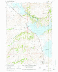
1961 Map of Glendo
USGS Topo · Published 1975About this map
Glendo Reservoir dominates the landscape in this early 1960s survey, illustrating the significant impact of the Missouri River Basin development on the Platte Valley. The town of Glendo sits south of the main reservoir body, served by the Chicago Burlington and Quincy railroad line that skirts the western edge of the water. The map traces the historical path of the Emigrant Trail cutting through the center of the quadrangle, providing a sharp contrast between nineteenth-century overland travel and the modern infrastructure of the Glendo State Park and local industrial efforts including several Quarries and Gravel Pits. Natural features like North Elkhorn Creek and Whiskey Gulch flow through the broken terrain of the Grey Hills, while family-named landmarks like Buffalo Springs offer specific points of interest for local history researchers.
Find a feature on this map
28 named features on this map. Tap any name to fly to it.
Don’t see what you’re looking for? This feature index may not catch every label — zoom into the map to look around manually.
Map Details
Editions of this 1961 Glendo Map
3 editions found
Other maps of this area

1896 · Hartville
USGS Topo · 1:125,000

1901 · Hartville
USGS Topo · 1:125,000

1949 · Shawnee
USGS Topo · 1:24,000

1949 · Cedar Hill
USGS Topo · 1:24,000

1949 · Spring Creek
USGS Topo · 1:24,000

1949 · Orin
USGS Topo · 1:24,000

1950 · Glendo
USGS Topo · 1:24,000

1950 · Spring Creek
USGS Topo · 1:24,000

1950 · Amend Ranch
USGS Topo · 1:24,000

1950 · Orin
USGS Topo · 1:24,000