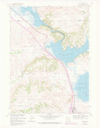
1961 Map of Glendo
USGS Topo · Published 1978About this map
The town of Glendo stands as a focal point in this 1961 survey, which illustrates the profound transformation of the local landscape following the impoundment of the North Platte River. Dominating the geography is the Glendo Reservoir, shown at its normal pool elevation of 4635 feet. This expansive body of water redefined the surrounding basin, creating the shoreline for what is now Glendo State Park. This particular edition includes 1976 revisions, marked in purple, which track the expansion of woodland areas and modifications to the local road network during the late 1970s.
Find a feature on this map
20 named features on this map. Tap any name to fly to it.
Don’t see what you’re looking for? This feature index may not catch every label — zoom into the map to look around manually.
Map Details
Editions of this 1961 Glendo Map
3 editions found
Other maps of this area

1896 · Hartville
USGS Topo · 1:125,000

1901 · Hartville
USGS Topo · 1:125,000

1949 · Shawnee
USGS Topo · 1:24,000

1949 · Cedar Hill
USGS Topo · 1:24,000

1949 · Spring Creek
USGS Topo · 1:24,000

1949 · Orin
USGS Topo · 1:24,000

1950 · Glendo
USGS Topo · 1:24,000

1950 · Spring Creek
USGS Topo · 1:24,000

1950 · Amend Ranch
USGS Topo · 1:24,000

1950 · Orin
USGS Topo · 1:24,000