1970s Maps of Ulm, Wyoming
Explore 2 historic maps of Ulm from the 1970s. These maps offer a rare glimpse into what life looked like during the 1970s — showing old roads, neighborhoods, homes, and landmarks that have changed or disappeared over time.
Whether you're researching your family's past, planning a metal detecting trip, or studying how Ulm's landscape evolved across the 1970s, these high-resolution maps are a powerful tool for exploring the history of this region.
- Focus on a specific era: All maps on this page are from the 1970s, giving you a focused view of this time period.
- See what’s changed: Compare century-old streets, trails, and buildings to today's modern landscape using overlays and satellite layers.
- Research with precision: Use these maps for genealogy, historical research, land use analysis, or educational projects.
- View, download, or print: Maps are fully viewable online in high resolution, and can be downloaded or printed for your own records.
Start exploring Ulm's history through authentic maps from the 1970s. This is your window into the past.
Ulm, WY maps
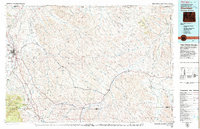
(2)- 1970 Map of Ulm, 1973 Print
 1970 Ulm1973 Print · USGSSheridan County, Wyoming, is captured here in the early seventies as a hub of ranching and rail. Genealogists and historians can trace the Burlington Northern line through Ulm and across many named landmarks like Lone Tree Creek and Pinhead Reservoir.
 - 1979 Map of Sheridan
 1979 Sheridan1979 Print · USGSSheridan and the surrounding ranching country are captured in the late seventies as the region balanced its frontier heritage with new energy development. Researchers can trace the path of the Burlington Northern railroad and locate historic landmarks like Massacre Hill and Lodge Trail Ridge.
End of results
Showing maps 1-2 of 2
Top cities near Ulm
Frequently asked questions
- What are the different types of historical maps available for Ulm?
- What is the oldest map of Ulm?
- Where can I purchase historical maps of Ulm for my home or office?
- Where can I download high-res historical maps of Ulm?
- Are there historical topographic maps available for Ulm?
- Is there historical aerial imagery available for Ulm?
- Where are historical maps of Ulm sourced from?