1980s Maps of Rocky Crossing, Wyoming
Explore 2 historic maps of Rocky Crossing from the 1980s. These maps offer a rare glimpse into what life looked like during the 1980s — showing old roads, neighborhoods, homes, and landmarks that have changed or disappeared over time.
Whether you're researching your family's past, planning a metal detecting trip, or studying how Rocky Crossing's landscape evolved across the 1980s, these high-resolution maps are a powerful tool for exploring the history of this region.
- Focus on a specific era: All maps on this page are from the 1980s, giving you a focused view of this time period.
- See what’s changed: Compare century-old streets, trails, and buildings to today's modern landscape using overlays and satellite layers.
- Research with precision: Use these maps for genealogy, historical research, land use analysis, or educational projects.
- View, download, or print: Maps are fully viewable online in high resolution, and can be downloaded or printed for your own records.
Start exploring Rocky Crossing's history through authentic maps from the 1980s. This is your window into the past.
Rocky Crossing, WY maps
(2)- 1984 Map of South Pass
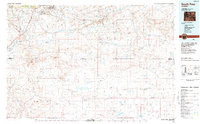 1984 South Pass1984 Print · USGSThe high Wyoming desert during the 1980s reveals a landscape where pioneer history and industrial mining converge. Trace the original paths of the Oregon Trail and Emigrant Trail past historic sites like South Pass City and the Tabor Grand Mine.2 unique versions available
 - 1989 Map of Bush Lake
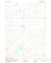 1989 Bush Lake1989 Print · USGSSweetwater County ranching and energy exploration are captured here in the late eighties. Researchers can locate remote landmarks like Luman Ranch, the waters of Bush Lake, and the historic Rocky Crossing over Red Creek.
End of results
Showing maps 1-2 of 2
Frequently asked questions
- What are the different types of historical maps available for Rocky Crossing?
- What is the oldest map of Rocky Crossing?
- Where can I purchase historical maps of Rocky Crossing for my home or office?
- Where can I download high-res historical maps of Rocky Crossing?
- Are there historical topographic maps available for Rocky Crossing?
- Is there historical aerial imagery available for Rocky Crossing?
- Where are historical maps of Rocky Crossing sourced from?