1900s (20th Century) Maps of Jackson, Wyoming
Explore 10 historic maps of Jackson from the 1900s (20th Century). These maps offer a rare glimpse into what life looked like during the 1900s — showing old roads, neighborhoods, homes, and landmarks that have changed or disappeared over time.
Whether you're researching your family's past, planning a metal detecting trip, or studying how Jackson's landscape evolved across the 1900s, these high-resolution maps are a powerful tool for exploring the history of this region.
- Focus on a specific era: All maps on this page are from the 1900s, giving you a focused view of this time period.
- See what’s changed: Compare century-old streets, trails, and buildings to today's modern landscape using overlays and satellite layers.
- Research with precision: Use these maps for genealogy, historical research, land use analysis, or educational projects.
- View, download, or print: Maps are fully viewable online in high resolution, and can be downloaded or printed for your own records.
Start exploring Jackson's history through authentic maps from the 1900s. This is your window into the past.
Jackson, WY maps
(10)- 1931 Map of Jackson, 1961 Print
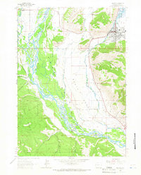
 1931 Jackson1961 Print · USGSJackson and the upper Snake River canyon are documented here in the early thirties, showcasing a wilderness era of ranching and forestry. Researchers can trace early outposts like Browns Ranch or locate family history at the Etna Cem and Johnny Counts Flat.
 - 1935 Map of Jackson
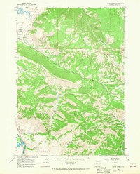
 1935 Jackson1935 Print · USGSThe high valleys of the Teton and Gros Ventre ranges are captured here in the mid-thirties, showing the early infrastructure of the upper Snake River region. Researchers can locate early schools and ranching outposts like Porcupine Sch, Browns Ranch, and the Jackson Mine.2 unique versions available
 - 1955 Map of Driggs, 1967 Print
 1955 Driggs1967 Print · USGSEastern Idaho and Western Wyoming appear at a mid-century crossroads as the river valleys were fully settled and the high peaks protected. Genealogists and researchers can trace the rail towns of Rexburg and Driggs or follow the Snake River from Irwin to the Palisades Reservoir.3 unique versions available
 - 1958 Map of Driggs
 1958 Driggs1958 Print · USGSThe high Teton peaks and Snake River valleys are captured here in the mid-fifties, showing the region's agricultural and wilderness boundaries. Researchers can trace the Union Pacific rail corridor through Rexburg or locate early settlements like Clementsville and Tetonia.2 unique versions available
 - 1962 Map of Driggs
 1962 Driggs1962 Print · USGSThe Idaho-Wyoming borderlands are captured here in the early sixties, showing the peaks and valleys of the northern Rockies. Genealogists and historians can trace rail lines like the Union Pacific RR and isolated outposts like the National Elk Refuge or the Fort Hall Indian Reservation.
 - 1963 Map of Jackson, 1966 Print
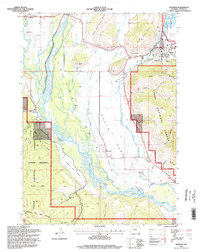
 1963 Jackson1966 Print · USGSJackson Hole and the Snake River valley are captured here in the early sixties as the regional infrastructure began to expand. Genealogists and local historians can trace early town footprints in Jackson and Wilson, or locate landmarks like Boyles Hill and the National Elk Refuge.3 unique versions available
 - 1965 Map of Cache Creek, 1968 Print
 1965 Cache Creek1968 Print · USGSThe peaks of the Gros Ventre Range tower over the Snake River valley in the mid-sixties, showing the rugged boundary between federal forest and wildlife refuge. Researchers can trace the steep paths of Jackson Mine and Noker Mine or locate the Refuge Hdqrs near the base of Nowlin Peak.2 unique versions available
 - 1981 Map of Jackson
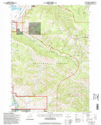
 1981 Jackson1981 Print · USGSThe high valleys and peaks surrounding Jackson were undergoing subtle transitions in the early eighties. Genealogists and researchers can trace old mountain outposts like Bondurant, the location of Camp Davis, and the roads leading to Astoria Mineral Hot Springs.
 - 1996 Map of Cache Creek, 1998 Print
 1996 Cache Creek1998 Print · USGSTeton County was a landscape of high-mountain wilderness and conservation at the close of the twentieth century. Researchers can trace the development of Jackson and locate historic mining sites such as the Jackson Mine and Noker Mine near the peaks of the Gros Ventre Range.
 - 1996 Map of Jackson, 1998 Print
 1996 Jackson1998 Print · USGSJackson and the Snake River valley appear here in the mid-1990s as the region's ranching roots met modern growth. Researchers can trace land use from Elk Refuge and Wilson to local landmarks like Aspen Hill Cemetery and the Melody Ranch.
End of results
Showing maps 1-10 of 10
Frequently asked questions
- What are the different types of historical maps available for Jackson?
- What is the oldest map of Jackson?
- Where can I purchase historical maps of Jackson for my home or office?
- Where can I download high-res historical maps of Jackson?
- Are there historical topographic maps available for Jackson?
- Is there historical aerial imagery available for Jackson?
- Where are historical maps of Jackson sourced from?