
1931 Map of Jackson
USGS Topo · Published 1961About this map
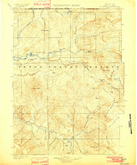
Jackson stands at the northern edge of this high mountain basin, where the Snake River winds south through a landscape dominated by massive uplifted ranges. Surveyed between 1927 and 1931, the map captures the region's early 20th-century character, defined more by remote outposts and forest administration than dense settlement. The presence of several backcountry stations, including the McCain Guard Sta and Bryan Flat Ranger Sta, reflects the active management of the Targhee National Forest and surrounding timberlands.
Find a feature on this map
101 named features on this map. Tap any name to fly to it.
Don’t see what you’re looking for? This feature index may not catch every label — zoom into the map to look around manually.
Map Details
Editions of this 1931 Jackson Map
This is the sole edition of this map. No revisions or reprints were ever made.
Other maps of this area

1899 · Grand Teton
USGS Topo · 1:125,000

1901 · Grand Teton
USGS Topo · 1:125,000
1902 · Mt Leidy
USGS Topo · 1:125,000

1907 · Gros Ventre
USGS Topo · 1:125,000

1910 · Gros Ventre
USGS Topo · 1:125,000

1915 · Freedom
USGS Topo · 1:62,500

1921 · Afton
USGS Topo · 1:125,000

1932 · Irwin
USGS Topo · 1:96,000

1935 · Irwin
USGS Topo · 1:125,000

1935 · Jackson
USGS Topo · 1:125,000