
1899 Map of Grand Teton
USGS Topo · Published 1954About this map
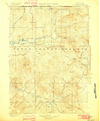
The Snake River corridor and its surrounding valley floor define this turn-of-the-century topographic landscape, where early ranching settlements like Grovont and Wilson established a human presence beneath the looming Teton Mountains. Surveyed just before the era of intensive park management, the map reveals a network of family-operated holdings along the riverbanks, including the Cunningham Ranch, Nelson's Ranch, and McBride's Ranch. These homesteads, alongside features like Teton Lodge, illustrate the early transition from isolated frontier ranching to the beginnings of alpine tourism.
Find a feature on this map
88 named features on this map. Tap any name to fly to it.
Don’t see what you’re looking for? This feature index may not catch every label — zoom into the map to look around manually.
Map Details
Editions of this 1899 Grand Teton Map
This is the sole edition of this map. No revisions or reprints were ever made.
Other maps of this area

1885 · Lake
USGS Topo · 1:125,000

1886 · Shoshone
USGS Topo · 1:125,000

1888 · Shoshone
USGS Topo · 1:125,000

1895 · Shoshone
USGS Topo · 1:125,000

1895 · Lake
USGS Topo · 1:125,000

1896 · Lake
USGS Topo · 1:125,000

1901 · Shoshone
USGS Topo · 1:125,000

1901 · Lake
USGS Topo · 1:125,000

1901 · Grand Teton
USGS Topo · 1:125,000
1902 · Mt Leidy
USGS Topo · 1:125,000