
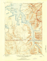
1885 Map of Lake
USGS Topo · Published 1885About this map
Two Ocean Pass serves as a remarkable hydrological centerpiece where the Continental Divide traverses the high wilderness south of Yellowstone Lake. In this high-altitude landscape, drainage patterns diverge toward the world's major oceans via Pacific Creek and Atlantic Creek, a phenomenon that defines the character of the Two Ocean Plateau. The eastern landscape is dominated by the Absaroka Range, featuring jagged landmarks such as The Trident, Turret, and Hawks Rest overlooking the upper Yellowstone River drainage.
Find a feature on this map
74 named features on this map. Tap any name to fly to it.
Don’t see what you’re looking for? This feature index may not catch every label — zoom into the map to look around manually.
Map Details
Editions of this 1885 Lake Map
2 editions found
Other maps of this area

1885 · Gallatin
USGS Topo · 1:125,000

1885 · Gallatin
USGS Topo · 1:125,000

1886 · Shoshone
USGS Topo · 1:125,000

1886 · Canyon
USGS Topo · 1:125,000

1888 · Shoshone
USGS Topo · 1:125,000

1893 · Ishawooa
USGS Topo · 1:125,000

1895 · Shoshone
USGS Topo · 1:125,000

1895 · Ishawooa
USGS Topo · 1:125,000

1895 · Canyon
USGS Topo · 1:125,000

1895 · Lake
USGS Topo · 1:125,000