
1885 Map of Gallatin
USGS Topo · Published 1886About this map
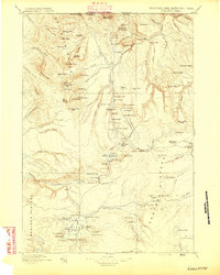
The Gardiner River and Gibbon River carve through the geothermal-active northwest corner of the park, as documented by surveyors J.H. Renshawe and Frank Tweedy. This early map reveals a landscape defined by natural wonders and the earliest tourism infrastructure, anchored by the Hotel at Mammoth Hot Springs. The survey captures the intricate hydrothermal features that made the area famous, including the Norris Geyser Basin and the striking Obsidian Cliff.
Find a feature on this map
123 named features on this map. Tap any name to fly to it.
Don’t see what you’re looking for? This feature index may not catch every label — zoom into the map to look around manually.
Map Details
Editions of this 1885 Gallatin Map
2 editions found
Other maps of this area

1885 · Lake
USGS Topo · 1:125,000

1885 · Gallatin
USGS Topo · 1:125,000

1886 · Shoshone
USGS Topo · 1:125,000

1886 · Canyon
USGS Topo · 1:125,000

1888 · Three Forks
USGS Topo · 1:250,000

1888 · Shoshone
USGS Topo · 1:125,000

1891 · Livingston
USGS Topo · 1:250,000

1893 · Livingston
USGS Topo · 1:250,000

1894 · Three Forks
USGS Topo · 1:250,000

1895 · Three Forks
USGS Topo · 1:250,000