Old Maps of Mammoth, Wyoming
Explore 12 old maps of Mammoth, spanning from 1885 to today. These high-resolution historic maps reveal how streets, neighborhoods, landmarks, and natural features evolved over time — perfect for genealogy, metal detecting, research, and local history exploration.
What you can do with these maps:
- See how Mammoth changed over time: Compare historical maps to modern-day views to trace roads, homesites, rail lines & more.
- View detailed metadata: Each map includes creators, publishers, year, scale, and archive source.
- Overlay maps with satellite & LiDAR: Visualize the past alongside modern tools to explore terrain & human change.
- Trusted historical sources: Maps sourced from the USGS, Library of Congress, and other archives.
- Access maps your way: View online, download high-res files, or order prints for personal or research use.
Start exploring old maps of Mammoth to uncover forgotten places, hidden landmarks, and the deep history beneath your feet.
Mammoth, WY maps
(12)- 1885 Map of Gallatin
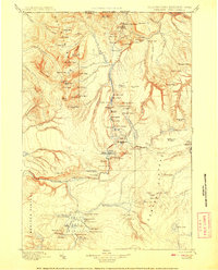
 1885 Gallatin1885 Print · USGSNorthwestern Yellowstone in the 1880s remains a wild expanse of thermal basins and high peaks just as early visitors were beginning to arrive. Geologists and historians can trace the early footprint of Mammoth Hot Springs, the Norris Geyser Basin, and landmarks like Obsidian Cliff.
 - 1885 Map of Gallatin, 1886 Print
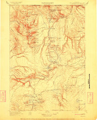
 1885 Gallatin1886 Print · USGSEarly park visitors and naturalists can trace the frontier-era geothermal landscape as it was first recorded in the mid-1880s. Identify original landmarks like the Hotel at Mammoth Hot Springs and the early topography of Norris Geyser Basin or Obsidian Cliff.2 unique versions available
 - 1901 Map of Gallatin
 1901 Gallatin1901 Print · USGSThe high plateau of the Yellowstone country appears here in the late nineteenth century, just as its hydrothermal wonders were becoming globally known. Researchers can locate early campsites and lodges near the Norris Geyser Basin, Obsidian Cliff, and Mammoth Hot Springs.
 - 1908 Map of Gallatin
 1908 Gallatin1908 Print · USGSYellowstone National Park in the early 1900s reveals a wilderness of hydrothermal wonders and early frontier outposts. Trace the locations of original park structures like Fort Yellowstone and thermal landmarks including Norris Geyser Basin and Beryl Spring.
 - 1911 Map of Gallatin
 1911 Gallatin1911 Print · USGSYellowstone's thermal wonders and early military outposts are recorded in detail just after the turn of the century. Researchers can trace the early road and trail systems connecting landmark sites like Fort Yellowstone, the Norris Geyser Basin, and the Fountain Hotel.2 unique versions available
 - 1955 Map of Ashton, 1967 Print
 1955 Ashton1967 Print · USGSThe Greater Yellowstone ecosystem is captured here during the mid-1950s, showing the high plateaus and remote gateway towns of Idaho and Montana. Researchers can trace the Union Pacific line to Ashton or locate small settlements like Squirrel and Grainville.4 unique versions available
 - 1958 Map of Ashton
 1958 Ashton1958 Print · USGSGreater Yellowstone and the eastern Idaho borderlands appear here in the mid-1950s as rail and road networks connected remote mountain basins. Trace the Union Pacific route through Ashton or locate early outposts like Last Chance, Squirrel, and West Yellowstone.
 - 1958 Map of Mammoth, 1960 Print
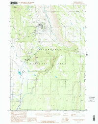
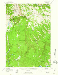 1958 Mammoth1960 Print · USGSYellowstone's northwest corner is documented here in the late fifties, showcasing the development of park headquarters and major geothermal landmarks. Researchers can locate the Cem, Mammoth Hot Springs, and early sites like the Indian Creek Campground.4 unique versions available
 - 1960 Map of Ashton
 1960 Ashton1960 Print · USGSThe Idaho-Montana-Wyoming borderlands at the dawn of the sixties show a landscape defined by the Continental Divide and early wilderness tourism. Genealogists and historians can trace rail-stop settlements like Trude Siding, old outposts like Warm River, and early lodging at Snowball Inn.
 - 1983 Map of Yellowstone National Park North
 1983 Yellowstone National Park North1983 Print · USGSThe northern wilderness of Wyoming and Montana is captured here in the early eighties, documenting the geothermal landmarks and early visitor infrastructure. Trace the historic paths of the Howard Eaton Trail or locate park icons like Mammoth Hot Springs and the Lake Hotel.
 - 1986 Map of Mammoth
 1986 Mammoth1986 Print · USGSYellowstone’s northern gateway and geothermal heart are captured here in the mid-eighties, showing the administrative and natural landscape at Mammoth. Researchers can locate specific travertine formations like Main Terrace or trace old routes through Kingman Pass and past Swan Lake.2 unique versions available
 - 2021 Map of Mammoth, 2021 Print
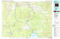
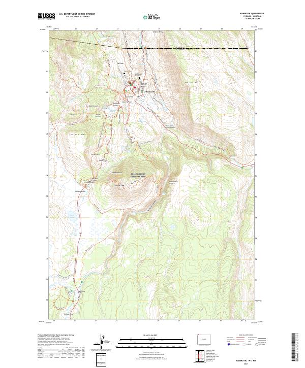 2021 Mammoth2021 Print · USGSYellowstone’s northern gateway near the Montana border is documented here in the modern era, centering on the administrative and military history of the park. Researchers can trace the grounds of Fort Yellowstone, find the Kite Hill Cem, and follow the Grand Loop Road past Opal Terrace.
End of results
Showing maps 1-12 of 12
Frequently asked questions
- What are the different types of historical maps available for Mammoth?
- What is the oldest map of Mammoth?
- Where can I purchase historical maps of Mammoth for my home or office?
- Where can I download high-res historical maps of Mammoth?
- Are there historical topographic maps available for Mammoth?
- Is there historical aerial imagery available for Mammoth?
- Where are historical maps of Mammoth sourced from?