
1895 Map of Shoshone
USGS Topo · Published 1895About this map
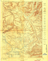
Upper Geyser Basin serves as a focal point for this late-nineteenth-century survey, documenting the early tourism infrastructure of the region including the Old Faithful Hotel. The map detail captures the high density of hydrothermal features along the Firehole River, including world-famous landmarks like Giant Geyser, Castle, and Beehive. Beyond the thermal basins, the terrain is defined by the high elevations of the Madison Plateau and Pitchstone Plateau, separated by the winding Continental Divide. To the east, the vast waters of Shoshone Lake and the Yellowstone Lake West Arm dominate the landscape. This 1895 edition also marks the Yellowstone Park Forest Reservation boundary, illustrating the early federal efforts to delineate and protect the surrounding wilderness area near the Red Mountains and peaks like Mt. Sheridan.
Find a feature on this map
83 named features on this map. Tap any name to fly to it.
Don’t see what you’re looking for? This feature index may not catch every label — zoom into the map to look around manually.
Map Details
Editions of this 1895 Shoshone Map
This is the sole edition of this map. No revisions or reprints were ever made.
Other maps of this area

1885 · Lake
USGS Topo · 1:125,000

1885 · Gallatin
USGS Topo · 1:125,000

1885 · Gallatin
USGS Topo · 1:125,000

1886 · Shoshone
USGS Topo · 1:125,000

1886 · Canyon
USGS Topo · 1:125,000

1888 · Shoshone
USGS Topo · 1:125,000

1895 · Canyon
USGS Topo · 1:125,000

1895 · Lake
USGS Topo · 1:125,000

1896 · Lake
USGS Topo · 1:125,000
1896 · Canyon
USGS Topo · 1:125,000