
1896 Map of Lake
USGS Topo · Published 1896About this map
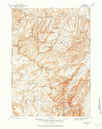
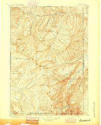
Yellowstone Lake dominates this 1885 survey of the high wilderness, showcasing the intricate shoreline of the South Arm and South East Arm. The topography, documented under the direction of Charles D. Walcott, captures the intersection of the Yellowstone National Park and the Yellowstone Park Forest Reservation. This era of mapping precedes modern infrastructure, focusing on the hydrologic network of the Yellowstone River and its major tributaries like Thorofare Creek and Atlantic Creek. High-altitude landmarks such as Mt Stevenson, Mt Schurz, and Eagle Peak define the eastern boundary, while the lone settlement at Hawks Rest and the waters of Bridger Lake offer a glimpse into the remote southern reaches of the park before the development of 20th-century tourism corridors. Geographer Henry Gannett ensured the inclusion of geothermal and geological curiosities like Brimstone Basin and Sylvan Pass, providing a detailed look at the landscape as it stood in the late nineteenth century.
Find a feature on this map
97 named features on this map. Tap any name to fly to it.
Don’t see what you’re looking for? This feature index may not catch every label — zoom into the map to look around manually.
Map Details
Editions of this 1896 Lake Map
This is the sole edition of this map. No revisions or reprints were ever made.
Other maps of this area

1885 · Lake
USGS Topo · 1:125,000

1885 · Gallatin
USGS Topo · 1:125,000

1885 · Gallatin
USGS Topo · 1:125,000

1886 · Shoshone
USGS Topo · 1:125,000

1886 · Canyon
USGS Topo · 1:125,000

1888 · Shoshone
USGS Topo · 1:125,000
1893 · Ishawooa
USGS Topo · 1:125,000

1895 · Shoshone
USGS Topo · 1:125,000
1895 · Ishawooa
USGS Topo · 1:125,000

1895 · Canyon
USGS Topo · 1:125,000