Old Maps of Fremont County, Wyoming
Explore 1,166 old maps of Fremont County, spanning from 1885 to today. These high-resolution historic maps reveal how streets, neighborhoods, landmarks, and natural features evolved over time — perfect for genealogy, metal detecting, research, and local history exploration.
What you can do with these maps:
- See how Fremont County changed over time: Compare historical maps to modern-day views to trace roads, homesites, rail lines & more.
- View detailed metadata: Each map includes creators, publishers, year, scale, and archive source.
- Overlay maps with satellite & LiDAR: Visualize the past alongside modern tools to explore terrain & human change.
- Trusted historical sources: Maps sourced from the USGS, Library of Congress, and other archives.
- Access maps your way: View online, download high-res files, or order prints for personal or research use.
Start exploring old maps of Fremont County to uncover forgotten places, hidden landmarks, and the deep history beneath your feet.
Fremont County, WY maps
(1,166)- 1885 Map of Lake
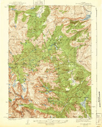
 1885 Lake1885 Print · USGSThe high wilderness south of Yellowstone Lake is captured here in the mid-1880s, showcasing the intricate hydrology of the Continental Divide. Researchers can trace the unique split of Pacific Creek and Atlantic Creek at Two Ocean Pass or locate early landmark peaks like The Trident and Mt Stevenson.2 unique versions available
 - 1895 Map of Lake
 1895 Lake1895 Print · USGSSoutheastern Yellowstone was a wild frontier of high passes and glacial lakes in the 1890s. Trace the complex alpine terrain around Yellowstone Lake, the waters of Heart Lake, and notable peaks like Mt Stevenson or Eagle Peak.
 - 1896 Map of Lake
 1896 Lake1896 Print · USGSThe high wilderness of the Wyoming Rockies is captured here in the late nineteenth century, just years after the park's establishment. Researchers can trace the wild southern reaches of Yellowstone Lake and find remote landmarks like Hawks Rest, Bridger Lake, and Brimstone Basin.
 - 1901 Map of Lake
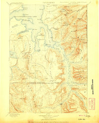
 1901 Lake1901 Print · USGSYellowstone's wilderness at the dawn of the twentieth century is charted here through its complex alpine hydrography and high-altitude peaks. Researchers can trace early park boundaries and remote landmarks like Hawks Rest, Brimstone Basin, and Frank Island.
 - 1902 Map of Mt Leidy
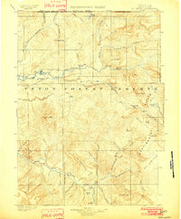 1902 Mt Leidy1902 Print · USGSTeton and Uinta counties are shown here at the turn of the century as a wilderness of forest reserves and high mountain passes. Researchers can trace early routes over the Continental Divide at Twogwotee Pass or locate the remote Dick Turpin Meadow.5 unique versions available
 - 1904 Map of Kirwin, 1957 Print
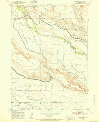
 1904 Kirwin1957 Print · USGSHigh-country mining and ranching define this region of the Absaroka Range at the turn of the century. Genealogists can trace family holdings like Double Diamond Ranch and Antler Ranch, or the high-altitude mining outpost at Kirwin.
 - 1905 Map of Younts Peak, 1955 Print
 1905 Younts Peak1955 Print · USGSThe upper Wind River valley and the Absaroka wilderness are captured here during the early ranching era. Local historians can trace the foundations of Dubois and locate early family homesteads like Rocking Chair Ranch, Nipper's Ranch, and the Clarks Placer Mines.2 unique versions available
 - 1906 Map of Lake
 1906 Lake1906 Print · USGSThe deep backcountry of Wyoming's wilderness is captured here in the 1880s as the park's southern reaches remained largely untamed. Trace the remote waters of Bridger Lake, the isolated outpost at Hawks Rest, and the hydrological curiosity of Two Ocean Pass.
 - 1906 Map of Kirwin
 1906 Kirwin1906 Print · USGSThe Absaroka Mountains and upper Wind River country are shown here in the early nineteen-hundreds during a period of active prospecting. Researchers can find old mining sites like the Gold Reef Tunnel and remote ranching hubs such as Kirwin and the Double Diamond Ranch.2 unique versions available
 - 1907 Map of Younts Peak
 1907 Younts Peak1907 Print · USGSNorthwestern Wyoming at the opening of the twentieth century was a landscape of remote mountain ranching and early forestry. Genealogists and historians can trace pioneer outposts like Rocking Chair Ranch and Dubois or locate Clarks Placer Mines.3 unique versions available
 - 1907 Map of Gros Ventre, 1957 Print
 1907 Gros Ventre1957 Print · USGSRanching life in the Wyoming high country is captured here during the first decade of the century, detailing the homesteads of the Gros Ventre Range. Researchers can trace the legacy of early settlers at Old Kendall and Kendall, or locate family-named landmarks like Loomis Ranch and Twin Creek School.
 - 1909 Map of Fremont Peak
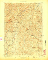
 1909 Fremont Peak1909 Print · USGSThe high peaks and early ranching outposts of the Wind River Range are captured here during the first decade of the 1900s. Researchers can locate remote homesteads like McShirley's Ranch and early forest service sites like Sawmill Ranger's Cabin.6 unique versions available
 - 1910 Map of Gros Ventre
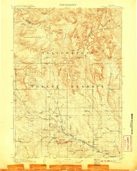
 1910 Gros Ventre1910 Print · USGSThe Gros Ventre Range is shown in the early twentieth century as a network of isolated family homesteads and early forest reserves. Genealogists and historians can trace pioneer roots at Bondurant, Twin Creek School, and Darwin Ranch.3 unique versions available
 - 1911 Map of Lake
 1911 Lake1911 Print · USGSYellowstone's southeastern wilderness is mapped here in the early twentieth century, showing the remote high plateaus and the intricate arms of the great lake. Researchers can trace the Continental Divide across Two Ocean Pass and locate isolated outposts like Snowshoe Cabin and Hawks Rest.2 unique versions available
 - 1937 Map of Moccasin Lake
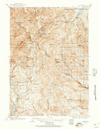
 1937 Moccasin Lake1937 Print · USGSThe high Wind River Range in the late thirties is documented here along the divide. Genealogists and researchers can trace early administrative outposts like Washakie Park Ranger Sta and North Fork Guard Sta among peaks like Mt Popo Agie.5 unique versions available
 - 1938 Map of Mt Bonneville, 1955 Print
 1938 Mt Bonneville1955 Print · USGSThe high alpine wilderness of Sublette and Fremont Counties is captured here in the late thirties, centered on the Continental Divide. Researchers can trace early forest service outposts like South Fork Guard Sta and the intricate path of the High Line Trail past Grave Lake and Mt Bonneville.6 unique versions available
 - 1941 Map of Mt Bonneville
 1941 Mt Bonneville1941 Print · USGSThe high country of the Wind River Range is captured here in the late thirties, documenting the remote alpine terrain of the Washakie National Forest. Researchers can trace historic backcountry routes like the High Line Trail and find isolated landmarks such as the John Day Cabin or Cow Camp.
 - 1942 Map of Mt Bonneville
 1942 Mt Bonneville1942 Print · USGSHigh mountain wilderness near the Fremont and Sublette County line is documented here in the late thirties. Researchers can locate remote outposts like the South Fork Guard Sta and John Day Cabin along the Continental Divide Trail.2 unique versions available
 - 1943 Map of Moccasin Lake
 1943 Moccasin Lake1943 Print · USGSThe Wind River high country is captured here just before the mid-century, spanning the Continental Divide and tribal lands. Researchers can trace the original Washakie Trail and locate remote outposts like the North Fork Guard Sta and Mosquito Park.2 unique versions available
 - 1950 Map of Riverton East, 1952 Print
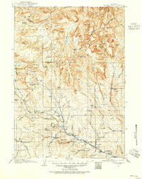
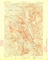
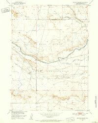
 1950 Riverton East1952 Print · USGSFremont County settlement and irrigation come alive in the early fifties, centering on the eastern outskirts of the reservation. Genealogists and researchers can trace local landmarks like Delfelder Hall, the Penitentiary Farm, and the Chicago and Northwestern rail line.3 unique versions available
 - 1950 Map of Pavillion, 1952 Print
 1950 Pavillion1952 Print · USGSMid-century Fremont County shows the transformation of the high plains through the massive Riverton Reclamation Project. Genealogists can locate family landmarks like the Grave of M B Kinnear, Morton School, and the settlement of Pavillion.
 - 1950 Map of Pavillion Butte, 1952 Print
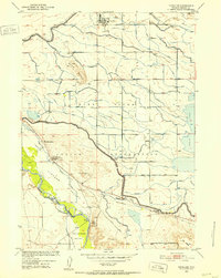
 1950 Pavillion Butte1952 Print · USGSFremont County's arid landscape underwent a massive transformation at mid-century through the irrigation works of the Riverton Reclamation Project. Genealogists and historians can trace the early infrastructure of the Wind River Indian Reservation, the original Wyoming Canal, and the Pavillion Airport.
 - 1950 Map of Harris Bridge, 1952 Print
 1950 Harris Bridge1952 Print · USGSFremont County irrigation and indigenous lands meet in this post-war survey of the Wind River Basin. Researchers can trace early water management along the Wyoming Canal and locate specific landmarks like Harris Bridge and Muddy Ridge.
 - 1950 Map of Mexican Pass SW, 1952 Print
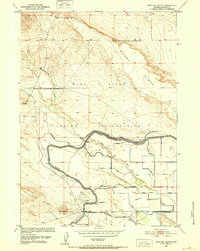
 1950 Mexican Pass SW1952 Print · USGSFremont County irrigation and ranching life are captured here at mid-century during the expansion of the Riverton Reclamation Project. Researchers can locate the Burnaugh Cem and trace the complex waterway network of the Wyoming Canal and Badger Lateral.
 - 1950 Map of Ocean Lake, 1952 Print
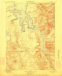
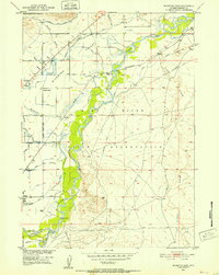
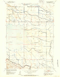 1950 Ocean Lake1952 Print · USGSThe Wind River Indian Reservation during the early fifties reveals a landscape reshaped by ambitious irrigation projects. Researchers can trace the engineering of Ocean Lake and its surrounding network of the Pilot Canal, Le Clair Ditch, and the settlement at Midvale.
Showing maps 1-25 of 1,166
Top cities of Fremont County
- Riverton historical maps
- Lander historical maps
- Fort Washakie historical maps
- Ethete historical maps
- Dubois historical maps
- Shoshoni historical maps
See more
Frequently asked questions
- What are the different types of historical maps available for Fremont County?
- What is the oldest map of Fremont County?
- Where can I purchase historical maps of Fremont County for my home or office?
- Where can I download high-res historical maps of Fremont County?
- Are there historical topographic maps available for Fremont County?
- Is there historical aerial imagery available for Fremont County?
- Where are historical maps of Fremont County sourced from?