1970s Maps of Fremont County, Wyoming
Explore 9 historic maps of Fremont County from the 1970s. These maps offer a rare glimpse into what life looked like during the 1970s — showing old roads, neighborhoods, homes, and landmarks that have changed or disappeared over time.
Whether you're researching your family's past, planning a metal detecting trip, or studying how Fremont County's landscape evolved across the 1970s, these high-resolution maps are a powerful tool for exploring the history of this region.
- Focus on a specific era: All maps on this page are from the 1970s, giving you a focused view of this time period.
- See what’s changed: Compare century-old streets, trails, and buildings to today's modern landscape using overlays and satellite layers.
- Research with precision: Use these maps for genealogy, historical research, land use analysis, or educational projects.
- View, download, or print: Maps are fully viewable online in high resolution, and can be downloaded or printed for your own records.
Start exploring Fremont County's history through authentic maps from the 1970s. This is your window into the past.
Fremont County, WY maps
(9)- 1970 Map of Younts Peak, 1973 Print
 1970 Younts Peak1973 Print · USGSThe Absaroka Range in the early 1970s reveals a wilderness of high peaks and river headwaters where the Continental Divide splits the county lines. Trace historic travel routes over Marston Pass or follow the Pack Trail along the South Fork Yellowstone River.2 unique versions available
 - 1970 Map of Ferry Lake, 1973 Print
 1970 Ferry Lake1973 Print · USGSThe Continental Divide crosses the high Teton Wilderness in the early seventies, marking the rugged boundary between Park and Fremont counties. Backcountry travelers can trace the historic Lake Fork Trail past Lake Fork Falls to Ferry Lake 9930.
 - 1970 Map of Hardluck Mountain, 1973 Print
 1970 Hardluck Mountain1973 Print · USGSThe high country of Park County is mapped here in the 1970s, showcasing a landscape of primitive trails and wilderness. Trace traditional pack routes like the South Fork Trail (Pack) to landmarks such as Hardluck Mountain and Cougar Pass.2 unique versions available
 - 1978 Map of Arapahoe NE, 1979 Print
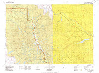
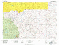
 1978 Arapahoe NE1979 Print · USGSThe Wind River Indian Reservation in the late seventies reveals an active landscape of energy extraction and transport. Genealogists and industrial historians can trace the network of Oil Wells, Pipelines, and local landmarks like Sevenmile Hill.
 - 1978 Map of Gannett Peak, 1979 Print
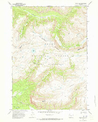
 1978 Gannett Peak1979 Print · USGSThe high peaks of the Wind River Range meet the plains in the late seventies. Researchers can trace the Continental Divide past Gannett Peak or locate riverfront settlements like Crowheart and Burris.2 unique versions available
 - 1978 Map of Lander, 1979 Print
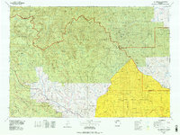
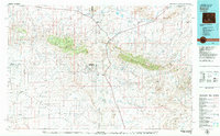
 1978 Lander1979 Print · USGSFremont County settlement and energy development are captured here in the late seventies. Trace historic western migrations along the EMIGRANT TRAIL and Baldwin Trail, or locate industrial sites like the Columbia-Geneva Mines and Dallas Oil Field.2 unique versions available
 - 1978 Map of The Ramshorn, 1979 Print
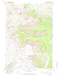
 1978 The Ramshorn1979 Print · USGSHigh Wyoming mountain country during the late seventies centers on the junction at Dubois, where the Wind River carves through the landscape. Researchers can trace the high-country drainages of the Yellowstone River or locate remote landmarks like Kirwin and Brooks Lake.2 unique versions available
 - 1978 Map of Lander, 1991 Print
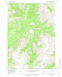
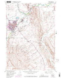 1978 Lander1991 Print · USGSLander and the Popo Agie River valley are shown here in the late seventies as the community grew between the river and the mountain ridges. Researchers can trace local history through sites like the Mt Hope Cem, the State Training Sch, and the Chicago and North Western Railroad.
 - 1979 Map of Bairoil, 1980 Print
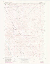
 1979 Bairoil1980 Print · USGSSouth-central Wyoming in the late 1970s was a landscape of remote energy outposts and high-desert ranges. Researchers can trace the industrial footprint of the Sunday Morning Mine and settlements like Bairoil and Jeffrey City.
End of results
Showing maps 1-9 of 9
Top cities of Fremont County
- Riverton historical maps
- Lander historical maps
- Fort Washakie historical maps
- Ethete historical maps
- Dubois historical maps
- Shoshoni historical maps
See more
Frequently asked questions
- What are the different types of historical maps available for Fremont County?
- What is the oldest map of Fremont County?
- Where can I purchase historical maps of Fremont County for my home or office?
- Where can I download high-res historical maps of Fremont County?
- Are there historical topographic maps available for Fremont County?
- Is there historical aerial imagery available for Fremont County?
- Where are historical maps of Fremont County sourced from?