1910s Maps of Fremont County, Wyoming
Explore 2 historic maps of Fremont County from the 1910s. These maps offer a rare glimpse into what life looked like during the 1910s — showing old roads, neighborhoods, homes, and landmarks that have changed or disappeared over time.
Whether you're researching your family's past, planning a metal detecting trip, or studying how Fremont County's landscape evolved across the 1910s, these high-resolution maps are a powerful tool for exploring the history of this region.
- Focus on a specific era: All maps on this page are from the 1910s, giving you a focused view of this time period.
- See what’s changed: Compare century-old streets, trails, and buildings to today's modern landscape using overlays and satellite layers.
- Research with precision: Use these maps for genealogy, historical research, land use analysis, or educational projects.
- View, download, or print: Maps are fully viewable online in high resolution, and can be downloaded or printed for your own records.
Start exploring Fremont County's history through authentic maps from the 1910s. This is your window into the past.
Fremont County, WY maps
(2)- 1910 Map of Gros Ventre
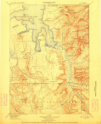
 1910 Gros Ventre1910 Print · USGSThe Gros Ventre Range is shown in the early twentieth century as a network of isolated family homesteads and early forest reserves. Genealogists and historians can trace pioneer roots at Bondurant, Twin Creek School, and Darwin Ranch.3 unique versions available
 - 1911 Map of Lake
 1911 Lake1911 Print · USGSYellowstone's southeastern wilderness is mapped here in the early twentieth century, showing the remote high plateaus and the intricate arms of the great lake. Researchers can trace the Continental Divide across Two Ocean Pass and locate isolated outposts like Snowshoe Cabin and Hawks Rest.2 unique versions available
End of results
Showing maps 1-2 of 2
Top cities of Fremont County
- Riverton historical maps
- Lander historical maps
- Fort Washakie historical maps
- Ethete historical maps
- Dubois historical maps
- Shoshoni historical maps
See more
Frequently asked questions
- What are the different types of historical maps available for Fremont County?
- What is the oldest map of Fremont County?
- Where can I purchase historical maps of Fremont County for my home or office?
- Where can I download high-res historical maps of Fremont County?
- Are there historical topographic maps available for Fremont County?
- Is there historical aerial imagery available for Fremont County?
- Where are historical maps of Fremont County sourced from?