
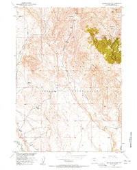
1950 Map of Mexican Pass SW
USGS Topo · Published 1952About this map
The Wind River Indian Reservation landscape in the early 1950s is defined here by an extensive network of irrigation infrastructure managed by the Bureau of Reclamation. The Wyoming Canal and its Wyoming Canal Extension carve through the terrain, supported by the Badger Lateral and numerous smaller Ditch segments. This engineering reflects the large-scale effort of the Riverton Reclamation Project (Withdrawal Area) to transform the arid Wyoming basin into productive agricultural land.
Find a feature on this map
14 named features on this map. Tap any name to fly to it.
Don’t see what you’re looking for? This feature index may not catch every label — zoom into the map to look around manually.
Map Details
Editions of this 1950 Mexican Pass SW Map
This is the sole edition of this map. No revisions or reprints were ever made.
Other maps of this area

1950 · Harris Bridge
USGS Topo · 1:24,000

1950 · Ocean Lake
USGS Topo · 1:24,000

1951 · Mexican Pass SE
USGS Topo · 1:24,000

1951 · Mexican Pass
USGS Topo · 1:24,000

1951 · Morrison Canyon
USGS Topo · 1:24,000

1951 · Jenkins Mountain
USGS Topo · 1:24,000

1952 · Riverton NE
USGS Topo · 1:24,000

1952 · Lost Wells Butte
USGS Topo · 1:24,000

1955 · Thermopolis
USGS Topo · 1:250,000
1957 · Jenkins Mountain
USGS Topo · 1:24,000