
1895 Map of Lake
USGS Topo · Published 1895About this map
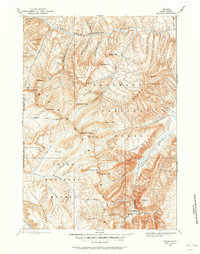
Yellowstone Lake dominates this late-nineteenth-century study of the park’s southeastern reaches, a landscape defined by glacial waters and the high peaks of the Absaroka Range. The map illustrates the complex hydrology of the Continental Divide, most famously at Two Ocean Pass, where waters part toward both the Atlantic and Pacific slopes. The intricate shoreline of the lake is documented in detail, from the Flat Mountain Arm to the South East Arm, featuring landmarks like Frank Island and the isolated Molly Island. To the east, the terrain rises sharply toward massive summits including Mt Stevenson and Mt Doane. This survey reflects an era of early park administration, showing the boundary line between the Yellowstone National Park and the Yellowstone Park Forest Reservation, a precursor to the modern national forest system.
Find a feature on this map
92 named features on this map. Tap any name to fly to it.
Don’t see what you’re looking for? This feature index may not catch every label — zoom into the map to look around manually.
Map Details
Editions of this 1895 Lake Map
This is the sole edition of this map. No revisions or reprints were ever made.
Other maps of this area

1885 · Lake
USGS Topo · 1:125,000

1885 · Gallatin
USGS Topo · 1:125,000

1885 · Gallatin
USGS Topo · 1:125,000

1886 · Shoshone
USGS Topo · 1:125,000

1886 · Canyon
USGS Topo · 1:125,000

1888 · Shoshone
USGS Topo · 1:125,000
1893 · Ishawooa
USGS Topo · 1:125,000

1895 · Shoshone
USGS Topo · 1:125,000
1895 · Ishawooa
USGS Topo · 1:125,000

1895 · Canyon
USGS Topo · 1:125,000