
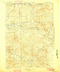
1907 Map of Gros Ventre
USGS Topo · Published 1957About this map
The Gros Ventre Range dominates this 1907 survey, a landscape defined by an early ranching economy and the high mountain terrain of western Wyoming. Deep within the Teton National Forest and Bridger National Forest, dozens of homesteads are recorded, including Lloyds Ranch, Darwin's Ranch, and Robinson's Ranch, mapping a period when private landholdings were sparse and tied closely to water sources like the Hoback River and Green River. Notable for local historians is the site of Kendall and Old Kendall near the riverbanks, as well as the isolated Twin Creek School. The map also captures natural landmarks such as Granite Falls and the nearby Hot Springs, providing a rare look at the area's development before it became primarily known for modern recreation and conservation.
Find a feature on this map
99 named features on this map. Tap any name to fly to it.
Don’t see what you’re looking for? This feature index may not catch every label — zoom into the map to look around manually.
Map Details
Editions of this 1907 Gros Ventre Map
This is the sole edition of this map. No revisions or reprints were ever made.
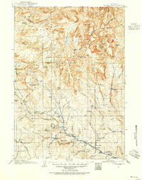
Other maps of this area

1899 · Grand Teton
USGS Topo · 1:125,000

1901 · Grand Teton
USGS Topo · 1:125,000
1902 · Mt Leidy
USGS Topo · 1:125,000
1905 · Younts Peak
USGS Topo · 1:125,000
1907 · Younts Peak
USGS Topo · 1:125,000
1909 · Fremont Peak
USGS Topo · 1:125,000

1910 · Gros Ventre
USGS Topo · 1:125,000

1921 · Afton
USGS Topo · 1:125,000

1931 · Jackson
USGS Topo · 1:125,000

1935 · Jackson
USGS Topo · 1:125,000