1960s Maps of Aspen, Wyoming
Explore 2 historic maps of Aspen from the 1960s. These maps offer a rare glimpse into what life looked like during the 1960s — showing old roads, neighborhoods, homes, and landmarks that have changed or disappeared over time.
Whether you're researching your family's past, planning a metal detecting trip, or studying how Aspen's landscape evolved across the 1960s, these high-resolution maps are a powerful tool for exploring the history of this region.
- Focus on a specific era: All maps on this page are from the 1960s, giving you a focused view of this time period.
- See what’s changed: Compare century-old streets, trails, and buildings to today's modern landscape using overlays and satellite layers.
- Research with precision: Use these maps for genealogy, historical research, land use analysis, or educational projects.
- View, download, or print: Maps are fully viewable online in high resolution, and can be downloaded or printed for your own records.
Start exploring Aspen's history through authentic maps from the 1960s. This is your window into the past.
Aspen, WY maps
(2)- 1960 Map of Ogden
 1960 Ogden1960 Print · USGSIn the mid-1950s, this region of the American West balanced military expansion with frontier history along the Union Pacific RR. Genealogists and historians can trace old settlements like Fort Bridger, the residential growth of Washington Terrace, and industrial sites from the Hill AFB complex to the coal mines of Kemmerer.
 - 1965 Map of Sulphur Creek Reservoir, 1968 Print
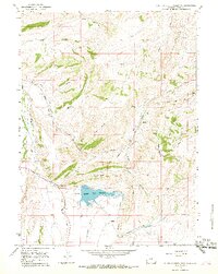 1965 Sulphur Creek Reservoir1968 Print · USGSUinta County's high ridges and valleys come alive in the mid-1960s, showing the critical intersection of transit and water management. Researchers can trace the path of the Emigrant Trail alongside industrial landmarks like the Union Pacific Railroad, Altamont, and the Sulphur Creek Reservoir.2 unique versions available
End of results
Showing maps 1-2 of 2
Top cities near Aspen
Frequently asked questions
- What are the different types of historical maps available for Aspen?
- What is the oldest map of Aspen?
- Where can I purchase historical maps of Aspen for my home or office?
- Where can I download high-res historical maps of Aspen?
- Are there historical topographic maps available for Aspen?
- Is there historical aerial imagery available for Aspen?
- Where are historical maps of Aspen sourced from?