1940s Maps of Colter, Wyoming
Explore 2 historic maps of Colter from the 1940s. These maps offer a rare glimpse into what life looked like during the 1940s — showing old roads, neighborhoods, homes, and landmarks that have changed or disappeared over time.
Whether you're researching your family's past, planning a metal detecting trip, or studying how Colter's landscape evolved across the 1940s, these high-resolution maps are a powerful tool for exploring the history of this region.
- Focus on a specific era: All maps on this page are from the 1940s, giving you a focused view of this time period.
- See what’s changed: Compare century-old streets, trails, and buildings to today's modern landscape using overlays and satellite layers.
- Research with precision: Use these maps for genealogy, historical research, land use analysis, or educational projects.
- View, download, or print: Maps are fully viewable online in high resolution, and can be downloaded or printed for your own records.
Start exploring Colter's history through authentic maps from the 1940s. This is your window into the past.
Colter, WY maps
(2)- 1945 Map of Kirby, 1958 Print
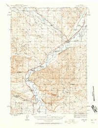 1945 Kirby1958 Print · USGSThe Bighorn River valley in the mid-1940s shows a region transitioning from its peak coal-mining years. Genealogists and historians can trace defunct operations like Crosby Mine, rail stops at Chatham Sta, and old frontier landmarks like The Willows (Old Stage Sta).2 unique versions available
 - 1946 Map of Kirby
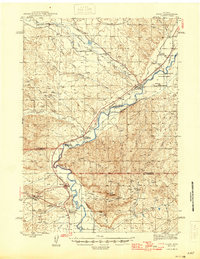 1946 Kirby1946 Print · USGSThe Bighorn River valley in the mid-1940s reveals a transition from active coal extraction to a rail-and-ranching economy. Researchers can locate the remnants of the Crosby Mine, the site of The Willows (Old Stage Sta), and the settlement of Gebo.
End of results
Showing maps 1-2 of 2
Top cities near Colter
Frequently asked questions
- What are the different types of historical maps available for Colter?
- What is the oldest map of Colter?
- Where can I purchase historical maps of Colter for my home or office?
- Where can I download high-res historical maps of Colter?
- Are there historical topographic maps available for Colter?
- Is there historical aerial imagery available for Colter?
- Where are historical maps of Colter sourced from?