1970s Maps of Osage, Wyoming
Explore 2 historic maps of Osage from the 1970s. These maps offer a rare glimpse into what life looked like during the 1970s — showing old roads, neighborhoods, homes, and landmarks that have changed or disappeared over time.
Whether you're researching your family's past, planning a metal detecting trip, or studying how Osage's landscape evolved across the 1970s, these high-resolution maps are a powerful tool for exploring the history of this region.
- Focus on a specific era: All maps on this page are from the 1970s, giving you a focused view of this time period.
- See what’s changed: Compare century-old streets, trails, and buildings to today's modern landscape using overlays and satellite layers.
- Research with precision: Use these maps for genealogy, historical research, land use analysis, or educational projects.
- View, download, or print: Maps are fully viewable online in high resolution, and can be downloaded or printed for your own records.
Start exploring Osage's history through authentic maps from the 1970s. This is your window into the past.
Osage, WY maps
(2)- 1972 Map of Osage, 1977 Print
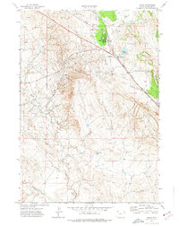 1972 Osage1977 Print · USGSOsage and its surrounding oil fields are captured here in the early 1970s, showcasing the industrial backbone of Weston County. Genealogists and historians can trace the intersection of the Burlington Northern railroad with local landmarks like the Power Plant and Claypits.
 - 1979 Map of Newcastle
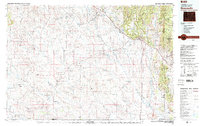 1979 Newcastle1979 Print · USGSThe energy-rich plains of Weston County meet the Black Hills in the late seventies as oil production and ranching define the landscape. Researchers can trace the Burlington Northern rail lines and explore the vast Fiddler Creek Oil Field or the remote Darlington School.
End of results
Showing maps 1-2 of 2
Top cities near Osage
Frequently asked questions
- What are the different types of historical maps available for Osage?
- What is the oldest map of Osage?
- Where can I purchase historical maps of Osage for my home or office?
- Where can I download high-res historical maps of Osage?
- Are there historical topographic maps available for Osage?
- Is there historical aerial imagery available for Osage?
- Where are historical maps of Osage sourced from?