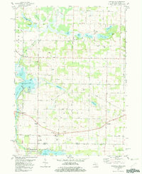
1981 Map of Adamsville
USGS Topo · Published 1982About this map
Adamsville and the surrounding rural landscape of Cass County, Michigan, appear here in the early 1980s, revealing a dense network of country roads and family-centric landmarks near the Indiana border. The map provides a detailed view of small communities such as Kessington, Allenton, and Pullman Corners, each situated along historic routes like Redfield Street and Mason Street. A significant number of local cemeteries, including Five Points Cem and Shaffer Cem, are preserved on this survey, offering essential data for genealogists tracing ancestral homesteads in Calvin and Mason townships.
Find a feature on this map
61 named features on this map. Tap any name to fly to it.
Don’t see what you’re looking for? This feature index may not catch every label — zoom into the map to look around manually.
Map Details
Editions of this 1981 Adamsville Map
This is the sole edition of this map. No revisions or reprints were ever made.
Other maps of this area

1945 · Cassopolis
USGS Topo · 1:62,500

1947 · Cassopolis
USGS Topo · 1:62,500

1948 · Vandalia
USGS Topo · 1:62,500

1949 · Vandalia
USGS Topo · 1:62,500

1953 · Fort Wayne
USGS Topo · 1:250,000

1953 · Chicago
USGS Topo · 1:250,000

1956 · Fort Wayne
USGS Topo · 1:250,000

1957 · Chicago
USGS Topo · 1:250,000

1958 · Osceola
USGS Topo · 1:24,000
1961 · Bristol
USGS Topo · 1:24,000