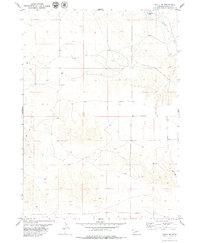
1979 Map of Agate NW
USGS Topo · Published 1979About this map
The Niobrara River winds through the northeast corner of this Sioux County landscape, a vital water source in an area of high plains and remote plateaus. Human presence is sparse, centered on rural infrastructure such as the Panhandle Sch and various water-management features including a Spillway and a Well. The terrain is marked by the utilitarian paths of the era, specifically a Jeep Trail that cuts across the western sections, indicating the limited accessibility and rugged nature of the High Plains. Evidence of local exploration or industrial activity appears at a single Drill Hole site, reflecting the periodic search for resources beneath the prairie. This survey, based on 1973 aerial photography, captures a moment before modern irrigation or development significantly altered the traditional ranching and grazing patterns of western Nebraska.
Find a feature on this map
8 named features on this map. Tap any name to fly to it.
Don’t see what you’re looking for? This feature index may not catch every label — zoom into the map to look around manually.
Map Details
Editions of this 1979 Agate NW Map
This is the sole edition of this map. No revisions or reprints were ever made.
Other maps of this area

1896 · Patrick
USGS Topo · 1:125,000

1899 · Whistle Creek
USGS Topo · 1:125,000

1954 · Torrington
USGS Topo · 1:250,000

1955 · Alliance
USGS Topo · 1:250,000

1957 · Alliance
USGS Topo · 1:250,000

1958 · Torrington
USGS Topo · 1:250,000

1958 · Alliance
USGS Topo · 1:250,000

1974 · Spoon Butte
USGS Topo · 1:24,000

1977 · Van Tassell SE
USGS Topo · 1:24,000
1978 · Torrington
USGS Topo · 1:100,000