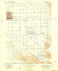
1955 Map of Alliance
USGS Topo · Published 1966About this map
Fort Robinson and the Fort Robinson Military Reservation anchor the northwest corner of this mid-century survey, illustrating the significant military and historical presence in the Nebraska panhandle. The landscape transitions from the jagged elevations of Pine Butte and Lookout Butte into the unique topography of the Sand Hills to the east and south. This era shows the region's dependence on the Niobrara River and White River systems, alongside early infrastructure like Box Butte Reservoir. Rural life is marked by small settlements and community centers such as Hemingford, Saint Marys Church, and Harrison School. The transportation network is defined by the Chicago and North Western and Chicago Burlington and Quincy railroads, which facilitated the growth of cattle and rail towns like Alliance and Chadron before the expansion of modern highways.
Find a feature on this map
86 named features on this map. Tap any name to fly to it.
Don’t see what you’re looking for? This feature index may not catch every label — zoom into the map to look around manually.
Map Details
Editions of this 1955 Alliance Map
3 editions found
Historical Maps of Alliance Through Time
5 maps found